Fraud Blocker Skip to main content

Boundaries Collection (page 6)

"Exploring Boundaries: Tracing the Historical Imprints of Scotland's Borders" This captivating satellite image showcases the intricate boundaries that define Scotland

Background imageBoundaries Collection: Agricultural landscape, Yorkshire Dales

Agricultural landscape, Yorkshire Dales, England. This landscape, at Malham, shows fields of different ages, separated by stone walls. Photographed in May

Background imageBoundaries Collection: Volcans d Auvergne, France

Volcans d Auvergne, France
Field boundaries with trees, near Le Mont-Dore in the Volcans d Auvergne Regional Natural Park, Massif Central in France

Background imageBoundaries Collection: Ancient limestone fields

Ancient limestone fields
Ancient limestone walled fields on Inisheer, the Burren, western Eire

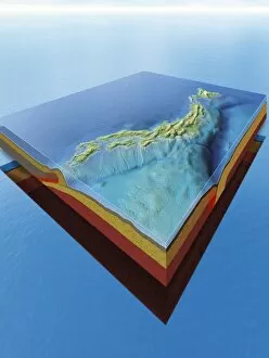
Background imageBoundaries Collection: Japans plate tectonics and cyclones

Japans plate tectonics and cyclones. Computer artwork showing cyclones (white spirals) travelling over the islands of Japan and the countrys underlying tectonic plates

Background imageBoundaries Collection: Earthquake types, artwork

Earthquake types, artwork
Earthquake types. Artwork showing tectonic plate movements (arrows) and associated earthquakes (red concentric rings). Tectonic plates moving parallel to each other (left)

Background imageBoundaries Collection: Tectonic plate boundaries, artwork

Tectonic plate boundaries, artwork
Tectonic plate boundaries. Artwork showing two types of boundary associated with the formation and destruction of an oceanic section of a tectonic plate

Background imageBoundaries Collection: Old field patterns, Turkey

Old field patterns, Turkey
Aerial view of old field patterns and boundaries on a spring evening at Cimikoy near Akseki, Taurus Mountains, south Turkey

Background imageBoundaries Collection: Field boundaries with trees in midwinter snow, near Le Mont-Dore in the Volcans d'Auvergne

Field boundaries with trees in midwinter snow, near Le Mont-Dore in the Volcans d'Auvergne Regional Natural Park
ROG-13891 Field boundaries with trees in midwinter snow, near Le Mont-Dore in the Volcans d'Auvergne Regional Natural Park Massif Central

Background imageBoundaries Collection: Flight - No more borders

Flight - No more borders
The turn of the twentieth century heralds the new age of flight, and a world of no borders or boundaries

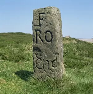
Background imageBoundaries Collection: Boundary stone, Hutton-le-Hole, North Yorkshire, England, United Kingdom, Europe

Boundary stone, Hutton-le-Hole, North Yorkshire, England, United Kingdom, Europe

Background imageBoundaries Collection: Field patterns of different ages at Malham, Yorkshire Dales. National Park

Field patterns of different ages at Malham, Yorkshire Dales. National Park
ROG-12278 Field patterns of different ages at Malham Yorkshire Dales, UK Bob Gibbons Please note that prints are for personal display purposes only and may not be reproduced in any way

Background imageBoundaries Collection: Fence posts through reeds

Fence posts through reeds, Isle of Harris, Outer Hebrides, Western Isles, Scotland, United Kingdom, Europe


All Professionally Made to Order for Quick Shipping

"Exploring Boundaries: Tracing the Historical Imprints of Scotland's Borders" This captivating satellite image showcases the intricate boundaries that define Scotland, UK. From the iconic London arms and seals to a fascinating map of Europe in 1360, these hints unravel a tale of territorial demarcations. Delving deeper into history, we discover an intriguing map depicting Westerham and Eatonbridge Hundred with the Parish and Ville of Brasted. This ancient document reveals how they were meticulously defined even centuries ago. The tradition of "Beating the Bounds Boats" comes alive through vivid images from 1930, where communities gathered to mark their territory along rivers and coastlines. These rituals symbolized unity while reinforcing geographical limits. They have always been subject to change as demonstrated by a passionate demonstration aiming to keep Horley and Charlwood within Surrey's embrace. The fence lining a country road serves as a reminder that borders can shape landscapes both physically and socially. Traveling back in time, we explore Victorian maps showcasing Great Marlow, Windsor, and Abingdon in 1832. These intricately detailed documents provide insights into how boundaries evolved over time while preserving historical landmarks. In this journey through space and time, we witness how they have shaped our world – defining nations, cultures, traditions – yet also reminding us that they are not fixed but constantly evolving reflections of human endeavors.