
Agnese Battista Collection
"Agnese Battista: Mapping the World in the 16th Century" Step into the fascinating world of Agnese Battista


All Professionally Made to Order for Quick Shipping
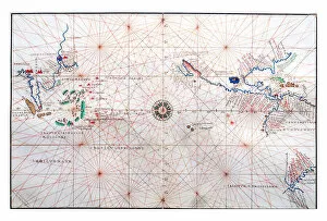
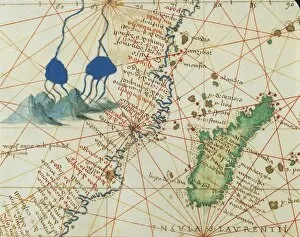
"Agnese Battista: Mapping the World in the 16th Century" Step into the fascinating world of Agnese Battista, a renowned cartographer who left an indelible mark on history with his intricate maps. His double-page map of the Atlantic Ocean reveals the east coast of North America, inviting us to explore its uncharted territories. Intriguingly, Battista's navigation chart showcases China, Ceylon, and the Philippines along with the Tropics of Cancer and Capricorn. This vellum masterpiece transports us back to a time when these distant lands were shrouded in mystery. Eastern Europe and Central Asia come alive through Battista's Atlas of the World in thirty-three Maps from 1553. Delicate lines trace borders as we journey through this vast region that was both familiar and unknown to those living during his time. The Indian Ocean takes center stage in another one of Battista's creations. With meticulous detail, he captures not only Asia and Africa but also highlights significant features such as the course of Nile River or Malaysia's islands Java and Sumatra. Battista's talent extends beyond continents; he delves into sacred lands too. Holy Land comes alive under his skilled hand as he depicts Israel and Palestine with precision. From Sea of Galilee to Tiberias city, each element is carefully etched onto paper. As we venture further westward across Northern Europe, Iceland emerges majestically on one of Battista's maps. Its rugged beauty captured for eternity within his Atlas – a testament to both exploration and artistry. The Pacific Ocean unfolds before our eyes through yet another creation by Agnese Battista. We are invited to imagine sailing across its vast expanse while marveling at how this great body connects diverse cultures separated by thousands of miles. From springing forth from Nile river in Africa to Madagascar off its eastern coast – every detail is meticulously portrayed in Battista's maps.