Fraud Blocker Skip to main content

Advanced Spaceborne Collection

"Exploring Earth's Wonders: A Glimpse into the Advanced Spaceborne World" Eastern Himalayas

Background imageAdvanced Spaceborne Collection: Eastern Himalayas, satellite image

Eastern Himalayas, satellite image. North is at top. Snow is white, vegetation is red, barren areas are light blue and water is dark blue

Background imageAdvanced Spaceborne Collection: Desert alluvial fan, satellite image

Desert alluvial fan, satellite image. North is at top. Desert areas can sometimes go for years without rain, and then intense storms will cause flooding that fills old dry river beds

Background imageAdvanced Spaceborne Collection: High-altitude clouds, satellite image

High-altitude clouds, satellite image. These swirling clouds are being shaped by high-altitude winds. They are over the Mediterranean Sea, just north of the coast of Morocco

Background imageAdvanced Spaceborne Collection: Plosky Tolbachik volcano erupting, 2013 C016 / 9732

Plosky Tolbachik volcano erupting, 2013 C016 / 9732
Plosky Tolbachik volcano erupting, satellite image. North is at top. This volcano (3682 metres) is located in Russias far eastern Kamchatka Peninsula

Background imageAdvanced Spaceborne Collection: Jebel Uweinat mountains, satellite image C016 / 9731

Jebel Uweinat mountains, satellite image C016 / 9731
Jebel Uweinat mountains, satellite image. North is at top. This mountain range (peak elevation: 1934 metres) is located on the Egyptian-Sudanese-Libyan border

Background imageAdvanced Spaceborne Collection: Coastal lagoons, satellite image

Coastal lagoons, satellite image. North is at top. Vegetation is red and water is blue. This area is on the western coast of Mexicos Yucatan Peninsula

Background imageAdvanced Spaceborne Collection: Rhine-Meuse delta, satellite image

Rhine-Meuse delta, satellite image. North is at top. Vegetation is red, barren areas are light blue, and water is dark blue

Background imageAdvanced Spaceborne Collection: Anti-Atlas mountains

Anti-Atlas mountains, Morocco, infrared satellite image. North is at top. This is at the western end of the Anti-Atlas Mountain Range in Morocco

Background imageAdvanced Spaceborne Collection: Mississippi Delta

Mississippi Delta. Coloured satellite image of the delta of the Mississippi River, USA. North is at top, the Gulf of Mexico is at lower left

Background imageAdvanced Spaceborne Collection: Lena River Delta, satellite image

Lena River Delta, satellite image
Lena River Delta. Satellite image of part of the delta of the Lena River. North is at top. Water is blue and wetland areas are green

Background imageAdvanced Spaceborne Collection: Saharan desert rivers, satellite image

Saharan desert rivers, satellite image. North is at top. Water is blue, desert areas are white, and fresh sediments and vegetation is orange/green

Background imageAdvanced Spaceborne Collection: Libyan Desert outcrop, satellite image

Libyan Desert outcrop, satellite image. North is at top. Sand dunes are white, less sandy areas are blue, and rock is dark grey

Background imageAdvanced Spaceborne Collection: Dry river beds, satellite image

Dry river beds, satellite image. North is at top. The bright blue areas are meandering wadis (dry river beds) that have formed in this desert area due to flooding

Background imageAdvanced Spaceborne Collection: Norwegian fjords, satellite image

Norwegian fjords, satellite image. North is at top. Water is black, snow is white and ice is blue. Glaciers (blue) are seen in several of the valleys, carrying ice down from the mountains to the sea

Background imageAdvanced Spaceborne Collection: Volcanic landscape, satellite image

Volcanic landscape, satellite image. North is at top. Desert sands and salt deposits are white, with the colour varying to light blue depending on the amount of rock content


All Professionally Made to Order for Quick Shipping

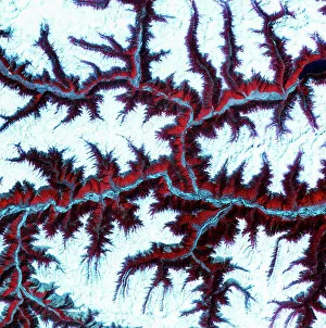
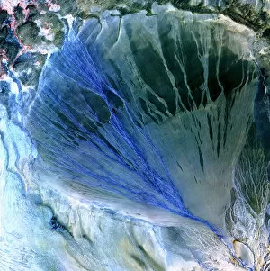
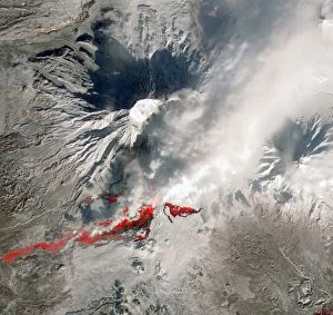
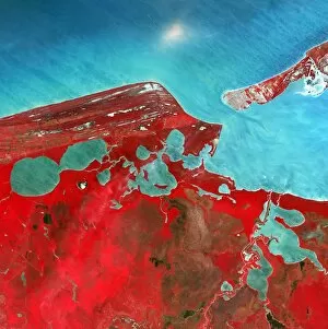
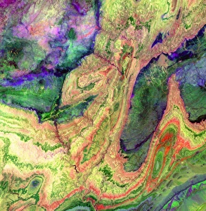
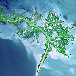
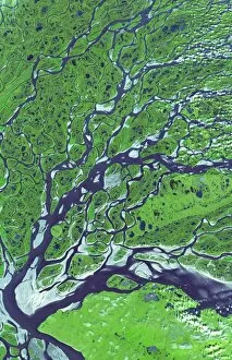
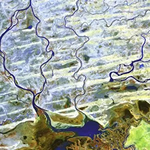
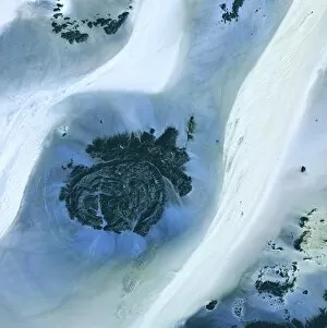
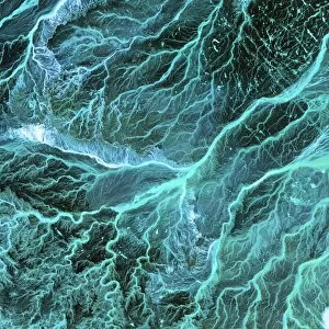
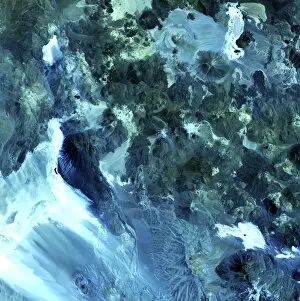
"Exploring Earth's Wonders: A Glimpse into the Advanced Spaceborne World" Eastern Himalayas, satellite image: Behold the majestic Eastern Himalayas from a bird's-eye view. This breathtaking satellite image captures the awe-inspiring beauty of one of nature's greatest wonders. Desert alluvial fan, satellite image: Witness the intricate patterns etched by time on this desert alluvial fan through our advanced spaceborne lens. Nature's artistry is truly mesmerizing. Merapi volcanic eruption, June 2006: Experience the raw power and intensity of Mother Nature as she unleashes her fury in this captivating satellite image capturing the explosive Merapi volcanic eruption back in June 2006. High-altitude clouds, satellite image: Delicate wisps of high-altitude clouds dance across our planet like ethereal brushstrokes on a canvas. Our advanced spaceborne technology brings you closer to these celestial marvels. Plosky Tolbachik volcano erupting, 2013 C016 / 9732: Immerse yourself in an inferno of molten lava and billowing ash with this extraordinary satellite image capturing the dramatic eruption of Plosky Tolbachik volcano in 2013. Jebel Uweinat mountains, satellite image C016 / 9731: Discover hidden treasures within Earth's rugged landscapes as we unveil a stunning satellite view showcasing the enigmatic Jebel Uweinat mountains' timeless allure. Coastal lagoons, satellite image: Dive into coastal serenity with our advanced spaceborne imagery that reveals pristine lagoons nestled along picturesque shorelines – nature's tranquil oasis for both land and sea creatures alike. Rhine-Meuse delta, satellite image: Embark on an aerial journey above Europe’s Rhine-Meuse delta as our cutting-edge satellites capture the intricate network of rivers and estuaries that shape this dynamic landscape.