Fraud Blocker Skip to main content

1684 1799 Collection

"Exploring the Seas

Background image1684 1799 Collection: Sea chart of the south coast of Cuba and Jamaica, Jan Luyken, Claes Jansz Voogt

Sea chart of the south coast of Cuba and Jamaica, Jan Luyken, Claes Jansz Voogt, Johannes van Keulen (I), 1684 - 1799

Background image1684 1799 Collection: Sea chart of part of southeastern Florida and northeast of Cuba, Jan Luyken, Claes

Sea chart of part of southeastern Florida and northeast of Cuba, Jan Luyken, Claes Jansz Voogt, Johannes van Keulen I, 1684-1799

Background image1684 1799 Collection: Sea chart of Bermuda, Jan Luyken, Claes Jansz Voogt, Johannes van Keulen (I), 1684 - 1799

Sea chart of Bermuda, Jan Luyken, Claes Jansz Voogt, Johannes van Keulen (I), 1684 - 1799

Background image1684 1799 Collection: Sea chart of part of the east coast of the United States USA, print maker: Jan Luyken

Sea chart of part of the east coast of the United States USA, print maker: Jan Luyken, Claes Jansz Voogt, Johannes van Keulen I, 1684 - 1799

Background image1684 1799 Collection: Sea chart of part of the coast of Suriname and Guyana, print maker: Jan Luyken, Claes

Sea chart of part of the coast of Suriname and Guyana, print maker: Jan Luyken, Claes Jansz Voogt, Johannes van Keulen I, 1684 - 1799

Background image1684 1799 Collection: Sea chart of the coast of French Guiana, Jan Luyken, Claes Jansz Voogt, Johannes van Keulen

Sea chart of the coast of French Guiana, Jan Luyken, Claes Jansz Voogt, Johannes van Keulen (I), 1684-1799

Background image1684 1799 Collection: Sea chart of the Gulf of Paria to the mouth of the Orinoco river, Orinoquia, Venezuela

Sea chart of the Gulf of Paria to the mouth of the Orinoco river, Orinoquia, Venezuela, Jan Luyken, Claes Jansz Voogt, Johannes van Keulen I, 1684-1799

Background image1684 1799 Collection: Sea chart of various Surinamese rivers, Jan Luyken, Johannes van Keulen (I), unknown

Sea chart of various Surinamese rivers, Jan Luyken, Johannes van Keulen (I), unknown, 1684 - 1799

Background image1684 1799 Collection: Sea chart of Puerto Rico, Jan Luyken, Claes Jansz Voogt, Johannes van Keulen (I)

Sea chart of Puerto Rico, Jan Luyken, Claes Jansz Voogt, Johannes van Keulen (I), 1684 - 1799

Background image1684 1799 Collection: Sea chart of Haiti, the Dominican Republic, Venezuela and Curacao and Aruba

Sea chart of Haiti, the Dominican Republic, Venezuela and Curacao and Aruba

Background image1684 1799 Collection: Sea chart of the north coast of Hispaniola, with two insert cards, print maker: Jan

Sea chart of the north coast of Hispaniola, with two insert cards, print maker: Jan Luyken, Claes Jansz Voogt, Johannes van Keulen I, 1684 - 1799

Background image1684 1799 Collection: Sea chart of the coasts of Colombia, Panama, Costa Rica and Honduras, with an inset

Sea chart of the coasts of Colombia, Panama, Costa Rica and Honduras, with an inset map of Cartagena, Jan Luyken, Claes Jansz Voogt, Johannes van Keulen (I), 1684 - 1799

Background image1684 1799 Collection: Sea chart of part of the Gulf of Mexico, with the coast of Florida, Jan Luyken, Claes

Sea chart of part of the Gulf of Mexico, with the coast of Florida, Jan Luyken, Claes Jansz Voogt, Johannes van Keulen (I), 1684 - 1799

Background image1684 1799 Collection: Sea chart of part of the coast of Virginia, Jan Luyken, Claes Jansz Voogt, Johannes van Keulen

Sea chart of part of the coast of Virginia, Jan Luyken, Claes Jansz Voogt, Johannes van Keulen (I), 1684 - 1799

Background image1684 1799 Collection: Sea chart of part of the east coast of the United States USA and Canada, print maker

Sea chart of part of the east coast of the United States USA and Canada, print maker: Jan Luyken, Claes Jansz Voogt, Johannes van Keulen I, 1684 - 1799

Background image1684 1799 Collection: Sea chart a part of the coast of northern Canada and Greenland, with two compass roses

Sea chart a part of the coast of northern Canada and Greenland, with two compass roses, the North is to the left, print maker: Jan Luyken, Dating 1684 - 1799


All Professionally Made to Order for Quick Shipping

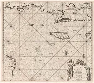
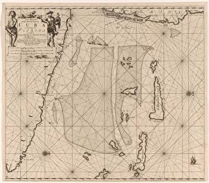
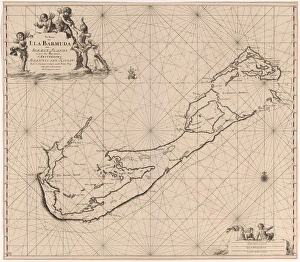
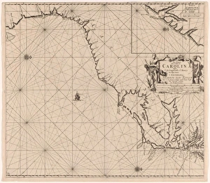
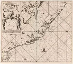
"Exploring the Seas: Jan Luyken's Captivating Charts from 1684 to 1799" Embark on a visual journey through time with Jan Luyken and Claes Jansz Voogt as they navigate the uncharted waters of the Caribbean and beyond. These remarkable sea charts, spanning from 1684 to 1799, offer a glimpse into the maritime world of exploration and discovery. In their meticulous craftsmanship, Luyken and Voogt bring to life the intricate details of these exotic locations. From a sea chart depicting the enchanting south coast of Cuba and Jamaica, we can almost feel the warm ocean breeze caressing our faces. The vibrant colors used by these skilled printmakers transport us to another era, where adventure awaited at every turn. Moving further eastward, we encounter a sea chart capturing part of southeastern Florida and northeast Cuba. Here, Luyken's artistry unveils an untamed landscape teeming with possibilities. As our eyes wander across this map, we envision intrepid explorers setting foot on unknown shores in search of new horizons. Venturing even deeper into unexplored territories, we discover a captivating sea chart showcasing Bermuda's mystique. With its intricate illustrations crafted by Johannes van Keulen (I), this map reveals hidden coves and treacherous reefs that challenged sailors for centuries. Continuing our voyage northwards along America's eastern coastlines, Luyken presents us with yet another masterpiece—a detailed sea chart mapping part of what would become known as the United States USA. This depiction serves as a testament to early cartography's importance in shaping nations' destinies. As we sail south once more towards South America, Luyken guides us through Suriname and Guyana's meandering rivers—an invaluable resource for traders seeking new routes amidst lush jungles brimming with potential riches. Further down along French Guiana's coastline lies another gem—a sea chart that beckons us to explore its untamed beauty.