Home > Europe > United Kingdom > England > Maps
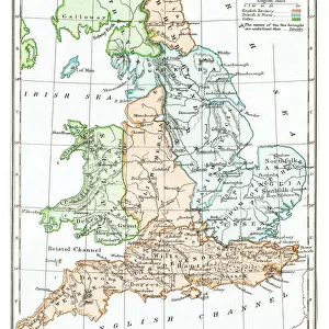
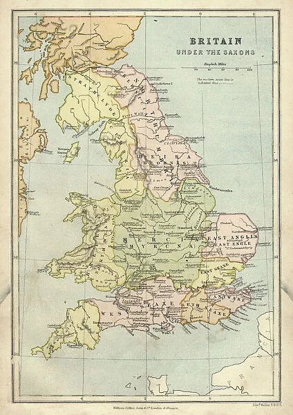
Canvas Print : Antique map of Britain under the Anglo Saxons


![]()
Canvas Prints from Fine Art Storehouse
Antique map of Britain under the Anglo Saxons
Unleash your creativity and transform your space into a visual masterpiece!
duncan1890
Media ID 14549471
© This content is subject to copyright
1870s Ancient Civilisation Ancient History Bad Condition British Colour Colours Condition English Equipment Faded Great Britain Image Created 1870 1879 Medieval Middle Ages Navigational Equipment Northern Europe Retro Saxon Styles Supplies Traditional United Kingdom
20"x16" (50x40cm) Canvas Print
Discover the rich history of Britain under the Anglo Saxons with our stunning Canvas Print by duncan1890 from the Media Storehouse Fine Art Collection. This intricately detailed antique map transports you back in time, showcasing the territories and kingdoms that once shaped the landscape of our island nation. The vibrant colors and textures of the canvas print bring the map to life, making it a captivating addition to any room in your home or office. Perfect for history enthusiasts, map collectors, or anyone who appreciates the beauty of historical art, this Canvas Print is sure to be a conversation starter and a source of inspiration for hours of exploration. Order yours today and let the story of Anglo Saxon Britain unfold before your eyes.
Ready to hang Premium Gloss Canvas Print. Our archival quality canvas prints are made from Polyester and Cotton mix and stretched over a 1.25" (32mm) kiln dried knot free wood stretcher bar. Packaged in a plastic bag and secured to a cardboard insert for transit.
Canvas Prints add colour, depth and texture to any space. Professionally Stretched Canvas over a hidden Wooden Box Frame and Ready to Hang
Estimated Image Size (if not cropped) is 35.9cm x 50.8cm (14.1" x 20")
Estimated Product Size is 40.6cm x 50.8cm (16" x 20")
These are individually made so all sizes are approximate
Artwork printed orientated as per the preview above, with portrait (vertical) orientation to match the source image.
FEATURES IN THESE COLLECTIONS
> Europe
> United Kingdom
> England
> Maps
> Europe
> United Kingdom
> England
> Paintings
> Fine Art Storehouse
> Map
> Historical Maps
> Fine Art Storehouse
> Top Sellers - Art Prints
> Historic
> Historical fashion trends
> Medieval fashion trends
> Maps and Charts
> Early Maps
> Maps and Charts
> Related Images
> Popular Themes
> Maps and Charts
EDITORS COMMENTS
This print takes us back in time to the ancient civilization of Britain under the rule of the Anglo Saxons. Created in the 1870s, this antique map showcases a remarkable piece of history with its intricate details and faded colors. Despite its bad condition, it exudes an undeniable charm that transports us to a bygone era. The engraving skillfully depicts the geographical landscape of Great Britain during medieval times, offering a glimpse into how navigational equipment was utilized during that period. The illustration and painting techniques employed in this image showcase traditional styles prevalent in 19th-century cartography. As we explore this vintage artwork, we can't help but appreciate the meticulous craftsmanship involved in creating such maps before modern technology took over. It serves as a reminder of our rich heritage and allows us to connect with our ancestors who once roamed these lands. Though worn by time, this print evokes a sense of nostalgia and curiosity about England's past. It invites us to delve deeper into British history and discover more about the fascinating Anglo Saxon era. Duncan1890 has preserved an important piece of European history through this lithograph, ensuring that future generations can admire and learn from it. This print is not just an old-fashioned relic; it is a window into our collective past – one that deserves appreciation for its cultural significance.
MADE IN THE UK
Safe Shipping with 30 Day Money Back Guarantee
FREE PERSONALISATION*
We are proud to offer a range of customisation features including Personalised Captions, Color Filters and Picture Zoom Tools
SECURE PAYMENTS
We happily accept a wide range of payment options so you can pay for the things you need in the way that is most convenient for you
* Options may vary by product and licensing agreement. Zoomed Pictures can be adjusted in the Basket.