Home > North America > United States of America > Montana > Missoula
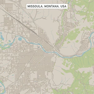
Missoula Montana US City Street Map

![]()
Wall Art and Photo Gifts from Fine Art Storehouse
Missoula Montana US City Street Map
Vector Illustration of a City Street Map of Missoula, Montana, USA. Scale 1:60, 000.
All source data is in the public domain.
U.S. Geological Survey, US Topo
Used Layers:
USGS The National Map: National Hydrography Dataset (NHD)
USGS The National Map: National Transportation Dataset (NTD)
Unleash your creativity and transform your space into a visual masterpiece!
Frank Ramspott
Media ID 15054931
© Frank Ramspott, all rights reserved
Aerial View City Map Computer Graphic Directly Above Downtown District Gray Montana Road Map Text Clark Fork Digitally Generated Image Green Color Missoula White Color
FEATURES IN THESE COLLECTIONS
> Aerial Photography
> Related Images
> Animals
> Insects
> Hemiptera
> Green Scale
> Arts
> Landscape paintings
> Waterfall and river artworks
> River artworks
> Arts
> Portraits
> Pop art gallery
> Street art portraits
> Fine Art Storehouse
> Map
> Street Maps
> Fine Art Storehouse
> Map
> USA Maps
> Maps and Charts
> Geological Map
> North America
> United States of America
> Lakes
> Related Images
> North America
> United States of America
> Maps
> North America
> United States of America
> Montana
> Missoula
EDITORS COMMENTS
This print showcases a meticulously detailed vector illustration of the vibrant city street map of Missoula, Montana, USA. With a scale of 1:60,000, every intricate feature is brought to life in this visually stunning artwork. The source data used for this creation is all in the public domain and comes from reputable sources such as the U. S. Geological Survey and US Topo. The layers utilized include the USGS National Hydrography Dataset (NHD) and National Transportation Dataset (NTD), ensuring accuracy and precision in depicting essential elements like rivers, lakes, streets, roads, and transportation networks within Missoula. This digitally generated image beautifully captures the essence of this charming city's downtown district along with its natural surroundings including Clark Fork River. Rendered in an array of colors such as gray, blue, white, and green against a backdrop that exudes tranquility; it provides viewers with an aerial view directly above Missoula. The absence of people allows one to focus solely on appreciating the artistry behind this cartographic masterpiece. Created by Frank Ramspott exclusively for Fine Art Storehouse – not just another company – this print exemplifies exceptional design skills combined with expertise in computer graphics. Whether you are a resident or simply captivated by maps and urban landscapes alike, this print will undoubtedly add sophistication to any space while celebrating the physical geography that defines Missoula's unique charm.
MADE IN THE UK
Safe Shipping with 30 Day Money Back Guarantee
FREE PERSONALISATION*
We are proud to offer a range of customisation features including Personalised Captions, Color Filters and Picture Zoom Tools
SECURE PAYMENTS
We happily accept a wide range of payment options so you can pay for the things you need in the way that is most convenient for you
* Options may vary by product and licensing agreement. Zoomed Pictures can be adjusted in the Basket.