Home > Europe > Greece > Maps
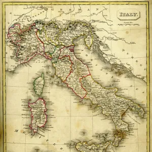
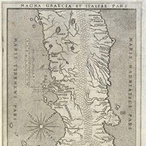
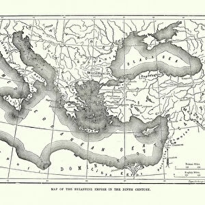
Vintage map of Magna Graecia

![]()
Wall Art and Photo Gifts from Fine Art Storehouse
Vintage map of Magna Graecia
Vintage map of Magna Graecia, showing the settlements of the ancient greeks in Italy. Magna GrA|cia is the name of the coastal areas of Southern Italy on the Tarentine Gulf that was extensively colonized by Greek settlers around the eighth century BC
Unleash your creativity and transform your space into a visual masterpiece!
duncan1890
Media ID 13666623
© duncan1890
Ancient Greece Ancient History Antiquities Classical Greek Condition Equipment European Culture Geographical Locations Greco Roman Greco Roman Style Historical Geopolitical Location Illustrations And Vector Art Italian Culture Magna Graecia Mediterranean Sea Navigational Equipment Past Sicily Southern Europe Styles Time Period Traditional Culture Travel Locations Classical Style Siracusa Province
FEATURES IN THESE COLLECTIONS
> Europe
> Italy
> Sicily
> Related Images
> Fine Art Storehouse
> Map
> Historical Maps
> Fine Art Storehouse
> Map
> Italian Maps
> Maps and Charts
> Early Maps
> Maps and Charts
> Italy
EDITORS COMMENTS
This vintage print showcases a meticulously detailed map of Magna Graecia, offering a glimpse into the ancient Greek settlements in Italy. The engraving beautifully captures the historical geopolitical location of this region, which was extensively colonized by Greek settlers around the eighth century BC. With its classical style and exquisite illustration technique, this woodcut transports us back to a time when European culture flourished amidst ancient civilizations. The print's antiquities evoke a sense of wonder and curiosity about the past, inviting us to explore the rich history and traditions of Italian culture. From Sicily to Siracusa Province, these geographical locations come alive on paper, reminding us of their significance in shaping Southern Europe's heritage. As we delve into this visual treasure trove, our eyes are drawn to navigational equipment scattered across the map—symbols that once guided sailors through Mediterranean waters. This adds an element of adventure and discovery to an already mesmerizing piece. With no people present in the image, we are left with ample room for imagination as we contemplate how life must have been during those ancient times. This vintage print is not just an illustration; it is a portal that allows us to travel back in time and immerse ourselves in classical Greek and Greco-Roman cultures. Duncan1890 has masterfully captured all these elements within this extraordinary artwork—a testament to his passion for archaeology and deep appreciation for historical beauty.
MADE IN THE UK
Safe Shipping with 30 Day Money Back Guarantee
FREE PERSONALISATION*
We are proud to offer a range of customisation features including Personalised Captions, Color Filters and Picture Zoom Tools
SECURE PAYMENTS
We happily accept a wide range of payment options so you can pay for the things you need in the way that is most convenient for you
* Options may vary by product and licensing agreement. Zoomed Pictures can be adjusted in the Basket.