Home > Europe > Iceland > Maps
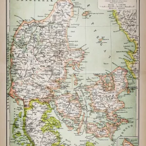
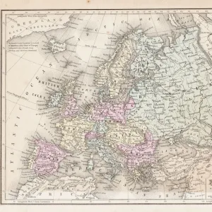
Old map of Scandinavia and Iceland, steel engraving, published 1857

![]()
Wall Art and Photo Gifts from Fine Art Storehouse
Old map of Scandinavia and Iceland, steel engraving, published 1857
Old map of Denmark, Sweden and Norway. Steel engraving with hand coloured borderlines, published in 1857
Unleash your creativity and transform your space into a visual masterpiece!
ZU_09
Media ID 19834475
FEATURES IN THESE COLLECTIONS
> Fine Art Storehouse
> Map
> Denmark Maps
> Fine Art Storehouse
> Map
> Historical Maps
> Maps and Charts
> Early Maps
EDITORS COMMENTS
This print takes us back in time to the year 1857, when this exquisite old map of Scandinavia and Iceland was first published. Crafted with meticulous detail, this steel engraving showcases the enchanting lands of Denmark, Sweden, and Norway. The artist's skilled hand has added a touch of color to highlight the intricate borderlines that define these majestic countries. As we gaze upon this vintage masterpiece, our imagination is transported to an era where cartography was both an art form and a scientific endeavor. Each line delicately etched on the map tells a story of exploration and discovery, capturing the essence of a bygone era. The rich history embedded within this print invites us to explore the vast landscapes depicted on its surface. From Denmark's charming coastal towns to Sweden's lush forests and Norway's breathtaking fjords - every inch holds secrets waiting to be unraveled. Beyond its historical significance, this print also serves as a reminder of how far we have come in our understanding of geography. It allows us to appreciate the dedication and skill required by those who meticulously mapped out these territories centuries ago. Whether displayed in a study or showcased in a living room gallery wall, this stunning piece from Fine Art Storehouse adds depth and character to any space while serving as an homage to our collective past.
MADE IN THE UK
Safe Shipping with 30 Day Money Back Guarantee
FREE PERSONALISATION*
We are proud to offer a range of customisation features including Personalised Captions, Color Filters and Picture Zoom Tools
SECURE PAYMENTS
We happily accept a wide range of payment options so you can pay for the things you need in the way that is most convenient for you
* Options may vary by product and licensing agreement. Zoomed Pictures can be adjusted in the Basket.