Home > Maps and Charts > Early Maps
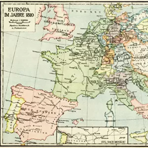
Napoleonic Europe

![]()
Wall Art and Photo Gifts from Fine Art Storehouse
Napoleonic Europe
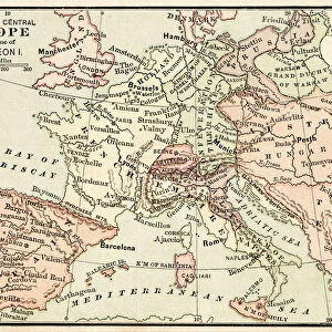
A map of Europe at the end of the Napoleonic Wars, 1815. The boundary of the German Confederation is marked in red, and boundary of Prussia in blue. (Photo by Hulton Archive/Getty Images)
Unleash your creativity and transform your space into a visual masterpiece!
Hulton Archive
Media ID 13609129
© 2011 Getty Images
1810 1819 Huty 16810 Napoleonic Wars
FEATURES IN THESE COLLECTIONS
> Europe
> Related Images
> Fine Art Storehouse
> Map
> Historical Maps
> Maps and Charts
> Early Maps
EDITORS COMMENTS
This print showcases a historical map of Europe at the conclusion of the Napoleonic Wars in 1815. The intricate details and vibrant colors bring to life the complex political landscape that emerged after years of conflict. In this image, we can observe the boundary lines of two significant entities: the German Confederation marked in striking red and Prussia delineated by bold blue lines. The aftermath of these wars brought about a reconfiguration of power across Europe, with borders being redrawn and new alliances formed. The German Confederation, represented by its distinctive red boundary, was an association of states that sought to maintain stability and balance amidst shifting geopolitical dynamics. Meanwhile, Prussia's presence is denoted by its unmistakable blue border. As one of the major players during this period, Prussia played a crucial role in shaping European politics and exerting influence over neighboring territories. This engraved image serves as both a historical artifact and an artistic masterpiece. It offers viewers a glimpse into a transformative era characterized by war, diplomacy, territorial disputes, and ultimately peace negotiations. By preserving this momentous snapshot from history through archival means, it allows us to reflect upon how events such as these have shaped our modern world today.
MADE IN THE UK
Safe Shipping with 30 Day Money Back Guarantee
FREE PERSONALISATION*
We are proud to offer a range of customisation features including Personalised Captions, Color Filters and Picture Zoom Tools
SECURE PAYMENTS
We happily accept a wide range of payment options so you can pay for the things you need in the way that is most convenient for you
* Options may vary by product and licensing agreement. Zoomed Pictures can be adjusted in the Basket.