Home > North America > Jamaica > Maps
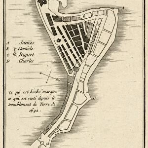
Map of Kingston and Port Royal, Jamaica, 19th Century

![]()
Wall Art and Photo Gifts from Fine Art Storehouse
Map of Kingston and Port Royal, Jamaica, 19th Century
Vintage engraving of a Map of Kingston and Port Royal, Jamaica, 19th Century
Unleash your creativity and transform your space into a visual masterpiece!
duncan1890
Media ID 14756366
© This content is subject to copyright
FEATURES IN THESE COLLECTIONS
> Fine Art Storehouse
> Map
> Historical Maps
> Maps and Charts
> Early Maps
> North America
> Jamaica
> Kingston
> North America
> Jamaica
> Maps
EDITORS COMMENTS
This vintage engraving takes us back to the 19th century, offering a glimpse into the rich history of Kingston and Port Royal in Jamaica. The intricate details of this map transport us to a time when these bustling Caribbean cities were at their peak. As we study the print, our eyes are drawn to the vibrant streets and architectural landmarks that once defined these coastal towns. Kingston, with its winding roads and bustling harbor, emerges as the heart of commerce and culture. Its strategic location made it a vital hub for trade during this era, evident from the numerous ships depicted on its shores. Meanwhile, Port Royal stands proudly adjacent to Kingston, showcasing its own unique charm with quaint buildings lining narrow alleyways. The artist's skillful rendering brings forth an air of nostalgia as we imagine what life was like in these thriving Jamaican communities centuries ago. Each stroke captures not only geographical accuracy but also conveys a sense of adventure and exploration that characterized this period. As we admire this historical treasure from Duncan1890's collection at Fine Art Storehouse, let us appreciate how far these cities have come since then while cherishing their past glory. This print serves as a reminder of our collective heritage and invites us to delve deeper into Jamaica's fascinating history – one that is intertwined with trade routes, colonialism, resilience, and cultural fusion.
MADE IN THE UK
Safe Shipping with 30 Day Money Back Guarantee
FREE PERSONALISATION*
We are proud to offer a range of customisation features including Personalised Captions, Color Filters and Picture Zoom Tools
SECURE PAYMENTS
We happily accept a wide range of payment options so you can pay for the things you need in the way that is most convenient for you
* Options may vary by product and licensing agreement. Zoomed Pictures can be adjusted in the Basket.