Home > Europe > Belgium > Maps
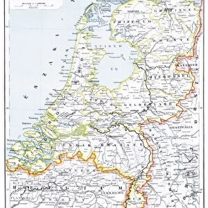
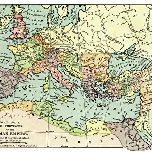
Map of Holland and Belgium 1896

![]()
Wall Art and Photo Gifts from Fine Art Storehouse
Map of Holland and Belgium 1896
Andres Allgemeiner Handatlas - Bielefeld und Leipzig 1896
Unleash your creativity and transform your space into a visual masterpiece!
THEPALMER
Media ID 18357009
FEATURES IN THESE COLLECTIONS
> Fine Art Storehouse
> Map
> Historical Maps
> Maps and Charts
> Early Maps
EDITORS COMMENTS
This print showcases a vintage map of Holland and Belgium from the year 1896. A true testament to cartographic artistry, this piece is taken from Andres Allgemeiner Handatlas - Bielefeld und Leipzig 1896, a renowned atlas that captured the essence of European geography during that era. The map's intricate details are beautifully preserved in this high-quality print by THEPALMER, available exclusively at Fine Art Storehouse. Transporting us back in time, this historic snapshot offers a glimpse into the past as it depicts the borders and topography of two neighboring countries. Every line and contour on this meticulously crafted map tells a story of exploration and discovery. From major cities to rivers, mountains to coastlines, every element is expertly rendered with precision. The sepia tones lend an air of nostalgia to the image, evoking a sense of wanderlust for those who appreciate both history and travel. Whether you have personal ties to these regions or simply admire their cultural heritage, this striking artwork serves as a visual reminder of how maps have shaped our understanding of the world throughout centuries. Perfect for home decor enthusiasts or avid collectors alike, "Map of Holland and Belgium 1896" invites you to embark on an imaginative journey through time while adding an elegant touch to any space. Immerse yourself in the rich tapestry of European history with this remarkable piece brought to life by THEPALMER's artistic vision – now available at Fine Art Storehouse.
MADE IN THE UK
Safe Shipping with 30 Day Money Back Guarantee
FREE PERSONALISATION*
We are proud to offer a range of customisation features including Personalised Captions, Color Filters and Picture Zoom Tools
SECURE PAYMENTS
We happily accept a wide range of payment options so you can pay for the things you need in the way that is most convenient for you
* Options may vary by product and licensing agreement. Zoomed Pictures can be adjusted in the Basket.