Home > Europe > Germany > Maps
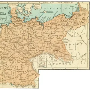
Map of Germany

![]()
Wall Art and Photo Gifts from Fine Art Storehouse
Map of Germany
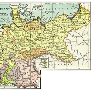
Map of Germany during the time of barbarian migration (500 AD). Woodcut, published in 1881
Unleash your creativity and transform your space into a visual masterpiece!
Media ID 14757190
© ZU_09
Ancient History Circa 5th Century Circa 6th Century Migrating
FEATURES IN THESE COLLECTIONS
> Fine Art Storehouse
> Map
> Historical Maps
> Maps and Charts
> Early Maps
EDITORS COMMENTS
This print showcases a remarkable woodcut map of Germany during the time of barbarian migration in 500 AD. Published in 1881, this engraved image offers us a glimpse into ancient history, specifically the tumultuous era of the 6th century. The intricate details and craftsmanship evident in this woodcut are truly awe-inspiring. As we delve into the depths of this etching, we are transported back to an era when tribes were on the move across Europe. The map vividly depicts Germany as it was during this transformative period, with various migratory routes crisscrossing its territories. It serves as a visual testament to the significant movements and cultural shifts that shaped European history. The artist's skillful rendering captures not only geographical accuracy but also conveys a sense of movement and dynamism through their masterful use of lines and shading techniques. Each stroke tells a story, inviting us to explore every corner of this historical landscape. Whether you are an avid historian or simply appreciate fine art, this woodcut map is sure to captivate your imagination. Its timeless appeal lies not only in its historical significance but also in its artistic merit—a true testament to human creativity throughout centuries.
MADE IN THE UK
Safe Shipping with 30 Day Money Back Guarantee
FREE PERSONALISATION*
We are proud to offer a range of customisation features including Personalised Captions, Color Filters and Picture Zoom Tools
SECURE PAYMENTS
We happily accept a wide range of payment options so you can pay for the things you need in the way that is most convenient for you
* Options may vary by product and licensing agreement. Zoomed Pictures can be adjusted in the Basket.