Home > Europe > France > Maps
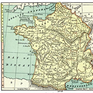
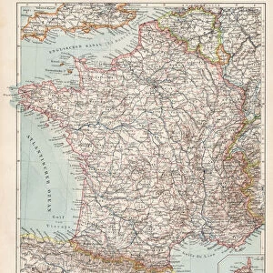
Map of France 1896

![]()
Wall Art and Photo Gifts from Fine Art Storehouse
Map of France 1896
Andres Allgemeiner Handatlas - Bielefeld und Leipzig 1896
Unleash your creativity and transform your space into a visual masterpiece!
THEPALMER
Media ID 18356849
FEATURES IN THESE COLLECTIONS
> Fine Art Storehouse
> Map
> Historical Maps
> Maps and Charts
> Early Maps
EDITORS COMMENTS
This print showcases a remarkable piece of history, the "Map of France 1896" from Andres Allgemeiner Handatlas. Dating back to the late 19th century, this meticulously detailed map offers us a glimpse into the past and allows us to explore France as it was over a century ago. With its intricate cartography and elegant design, this vintage map is not just an ordinary geographical representation but also a work of art. The fine craftsmanship and attention to detail are evident in every line and contour, capturing the essence of French geography with precision. As we delve into this historical treasure, we can trace our fingers along ancient borders, rivers, cities, and regions that have shaped France's rich cultural heritage. From bustling Paris to picturesque coastal towns like Nice or Marseille; from majestic mountain ranges like the Alps to fertile valleys such as Loire or Rhône – each corner of this enchanting country unfolds before our eyes. The sepia-toned hues add an air of nostalgia to this print while preserving its authenticity. It serves as a reminder of how much has changed since 1896 while honoring the enduring beauty and significance of France's landscape throughout time. Whether you are an avid historian or simply appreciate timeless artwork, this "Map of France 1896" by THEPALMER is sure to captivate your imagination and transport you back in time.
MADE IN THE UK
Safe Shipping with 30 Day Money Back Guarantee
FREE PERSONALISATION*
We are proud to offer a range of customisation features including Personalised Captions, Color Filters and Picture Zoom Tools
SECURE PAYMENTS
We happily accept a wide range of payment options so you can pay for the things you need in the way that is most convenient for you
* Options may vary by product and licensing agreement. Zoomed Pictures can be adjusted in the Basket.