Home > Africa > Eritrea > Maps
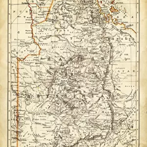
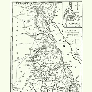
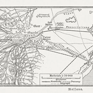
Map of Egypt, Darfur, and Abyssinia, lithograph, published in 1897

![]()
Wall Art and Photo Gifts from Fine Art Storehouse
Map of Egypt, Darfur, and Abyssinia, lithograph, published in 1897
Map of Egypt, Darfur, and Abyssinia with separate map of the Nile Delta and Suez Canal. Lithograph, published in 1897
Unleash your creativity and transform your space into a visual masterpiece!
Media ID 14756394
© This content is subject to copyright
Abyssinia African Culture Arabia Cairo Country Egypt Mediterranean Sea Nile Nubia Red Sea Sinai Sudan Suez Canal Darfur Eritrea
FEATURES IN THESE COLLECTIONS
> Fine Art Storehouse
> Map
> Historical Maps
> Maps and Charts
> Early Maps
EDITORS COMMENTS
This lithograph, published in 1897, showcases a detailed "Map of Egypt, Darfur, and Abyssinia" along with a separate map highlighting the Nile Delta and Suez Canal. The intricate engravings on this vertical print offer a glimpse into the rich history and cultural tapestry of Africa. The main map encompasses vast regions including Egypt, Darfur (now part of Sudan), Eritrea (formerly Abyssinia), Nubia, and even stretches as far as Yemen and Arabia. It beautifully captures the diverse landscapes that define these countries - from the majestic Red Sea to the historic Nile River winding through Cairo towards Sudan. As we delve deeper into this historical artwork, it becomes evident that it serves not only as a geographical reference but also an exploration of African culture. Each stroke on this lithograph tells stories of ancient civilizations thriving along the banks of the Nile or trading routes connecting distant lands. The inclusion of additional maps showcasing key landmarks like the Suez Canal emphasizes its significance in global trade during that era. This print transports us back to a time when maritime commerce flourished between Europe and Asia through this vital waterway. Preserved for over a century, this lithograph is more than just an artistic masterpiece; it is an invaluable window into our past. Its intricate details invite viewers to embark on a visual journey through time while appreciating Africa's enduring legacy in shaping world history.
MADE IN THE UK
Safe Shipping with 30 Day Money Back Guarantee
FREE PERSONALISATION*
We are proud to offer a range of customisation features including Personalised Captions, Color Filters and Picture Zoom Tools
SECURE PAYMENTS
We happily accept a wide range of payment options so you can pay for the things you need in the way that is most convenient for you
* Options may vary by product and licensing agreement. Zoomed Pictures can be adjusted in the Basket.