Home > Europe > Italy > Lazio > Rome
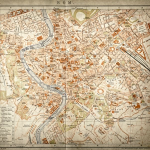
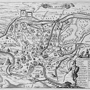
Map of Ancient Rome

![]()
Wall Art and Photo Gifts from Fine Art Storehouse
Map of Ancient Rome
Vintage engraving showing a plan of Ancient Rome
Unleash your creativity and transform your space into a visual masterpiece!
duncan1890
Media ID 13666617
© duncan1890
Ancient History Ancient Rome Antiquities Capitol Capitol Rome Condition Document Empire Ephemera Historical Document Illustrations And Vector Art Information Equipment Italian Culture Lazio Manufactured Object Navigational Equipment Objects Equipment Past Plan Printed Media Relief Map Roman Roman Forum Rome Southern Europe Styles Time Period Travel Locations Classical Style Palatine Hill
FEATURES IN THESE COLLECTIONS
> Europe
> Italy
> Lazio
> Rome
> Fine Art Storehouse
> Map
> Historical Maps
> Fine Art Storehouse
> Map
> Italian Maps
> Maps and Charts
> Early Maps
> Maps and Charts
> Italy
EDITORS COMMENTS
This vintage engraving showcases a captivating "Map of Ancient Rome" offering us a glimpse into the majestic city's layout during its prime. Dating back to ancient history, this remarkable artifact immerses us in the grandeur of an ancient civilization that once thrived on Palatine Hill. The meticulously engraved image depicts the sprawling Roman Empire, with notable landmarks such as the Capitol and Roman Forum prominently featured. The illustration technique employed in this historical document is truly impressive, capturing every intricate detail with precision and finesse. As we explore this relief map, we are transported back in time to witness the classical style and architectural marvels that defined ancient Rome. Preserved through centuries, this antique print serves as a window into our past—a testament to human ingenuity and cultural heritage. Its condition speaks volumes about its age and significance, evoking a sense of reverence for those who appreciate archaeology and historical artifacts. As we study this navigational equipment from 182708330, it becomes clear how cartography played an essential role in documenting travel locations during that era. This manufactured object holds immense value not only for its informational purposes but also for its artistic merit. Capturing an international landmark without any people present allows us to focus solely on the magnificence of Rome's capitol while appreciating Italian culture at its core. Duncan1890 has masterfully captured this timeless piece through photography, ensuring that future generations can admire and learn from it within their own homes or institutions dedicated to preserving our rich history.
MADE IN THE UK
Safe Shipping with 30 Day Money Back Guarantee
FREE PERSONALISATION*
We are proud to offer a range of customisation features including Personalised Captions, Color Filters and Picture Zoom Tools
SECURE PAYMENTS
We happily accept a wide range of payment options so you can pay for the things you need in the way that is most convenient for you
* Options may vary by product and licensing agreement. Zoomed Pictures can be adjusted in the Basket.