Home > Animals > Mammals > Elephantidae > African Elephant
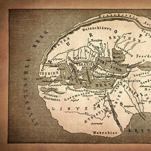
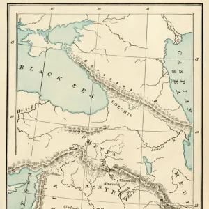
Distorted antique map of Africa

![]()
Wall Art and Photo Gifts from Fine Art Storehouse
Distorted antique map of Africa
Unleash your creativity and transform your space into a visual masterpiece!
Hemera Technologies
Media ID 13667371
© Getty Images
16th Century 16th Century Style African Animal Likeness Animal Representation Arabia Atlantic Atlantic Ocean Cartouche Continent Distorted Distorted Image Document Egypt Elephant Geography German Culture Human Likeness Human Representation Indian Ocean Lakes Legend Libya Munster Nubia Ornamental Ornate Red Sea Rivers Ship Ships Syria Text Title Words Distortion
FEATURES IN THESE COLLECTIONS
> Africa
> Egypt
> Lakes
> Related Images
> Animals
> Mammals
> African Elephant
> Animals
> Mammals
> Elephantidae
> African Elephant
> Arts
> Landscape paintings
> Waterfall and river artworks
> River artworks
> Arts
> Portraits
> Animal portraiture
> Fine art photography
> Fine Art Storehouse
> Map
> Historical Maps
> Maps and Charts
> Early Maps
EDITORS COMMENTS
This print showcases a distorted antique map of Africa, dating back to the 16th century. The rich historical significance and intricate details make it a true masterpiece of cartography. Created by Hemera Technologies, this image captures the essence of ancient African geography with its depiction of rivers, mountains, lakes, and even animal likenesses. The ornate woodcut engraving features an array of vibrant colors that bring life to the vintage artwork. The map's cartouche proudly displays its title and key, providing valuable information for navigation in times long past. As you explore this piece further, you'll notice references to Arabian lands and Indian Ocean routes that were crucial during those times. The inclusion of human likeness adds a touch of cultural representation to this remarkable piece. It serves as a reminder not only of Africa's physical geography but also its diverse population throughout history. With no people present in the image itself, one can fully immerse themselves in the beauty and complexity of this historic artifact. Whether you are an avid collector or simply appreciate art with a historical flair, this distorted antique map is sure to captivate your imagination and transport you back centuries into Africa's fascinating past.
MADE IN THE UK
Safe Shipping with 30 Day Money Back Guarantee
FREE PERSONALISATION*
We are proud to offer a range of customisation features including Personalised Captions, Color Filters and Picture Zoom Tools
SECURE PAYMENTS
We happily accept a wide range of payment options so you can pay for the things you need in the way that is most convenient for you
* Options may vary by product and licensing agreement. Zoomed Pictures can be adjusted in the Basket.