Home > Asia > Iraq > Maps
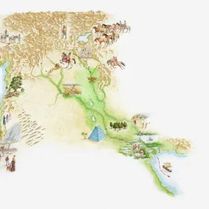
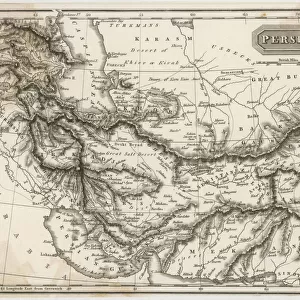
Assyria and Phersia Empire c. 500 BC, steel engraving, published 1661

![]()
Wall Art and Photo Gifts from Fine Art Storehouse
Assyria and Phersia Empire c. 500 BC, steel engraving, published 1661
Antique map from Assyrian and Persian Empire, c. 500 BC. Legend in Latin language. Steel engraving with hand colored borderlines, published in 1861
Unleash your creativity and transform your space into a visual masterpiece!
Media ID 13666855
© ZU_09
Afrika Afrika Arabia Asian And Indian Ethnicities Asian Ethnicity Assyria Assyrian Babil Carthage Tunisia East Asian Ethnicity Empire Ethnocultural History India Iran Iraq Latin Script Mediterranean Countries Mediterranean Sea Middle East Persian Culture Social History Steel Engraving Topography
FEATURES IN THESE COLLECTIONS
> Europe
> Related Images
> Fine Art Storehouse
> Map
> Historical Maps
> Maps and Charts
> Early Maps
> Maps and Charts
> India
EDITORS COMMENTS
This steel engraving, published in 1661, showcases an antique map of the Assyrian and Persian Empires circa 500 BC. The intricate details and hand-colored borderlines bring to life the rich history of these ancient civilizations. With a legend written in Latin, this print offers a glimpse into the topography and social history of Mediterranean countries during that era. The image spans horizontally, capturing not only Carthage in Tunisia but also other significant regions such as Babil (Babylon), Arabia, Iraq, Iran, India, Europe, Africa, and the Mediterranean Sea. It serves as a visual testament to the vast extent of these empires' influence across Asia and beyond. As we delve into this ethnocultural history through engraved imagery and etching techniques employed by skilled artisans centuries ago, we are reminded of the diverse ethnicities that contributed to shaping these empires. From Asian to Indian backgrounds represented on this map alone speaks volumes about their interconnectedness with Assyria and Persia. This photograph transports us back in time—allowing us to appreciate both the grandeur of ancient civilizations and their lasting impact on our present world. Whether you are an avid historian or simply fascinated by antiquity's allure, this print is sure to captivate your imagination with its blend of artistry and historical significance.
MADE IN THE UK
Safe Shipping with 30 Day Money Back Guarantee
FREE PERSONALISATION*
We are proud to offer a range of customisation features including Personalised Captions, Color Filters and Picture Zoom Tools
SECURE PAYMENTS
We happily accept a wide range of payment options so you can pay for the things you need in the way that is most convenient for you
* Options may vary by product and licensing agreement. Zoomed Pictures can be adjusted in the Basket.