Home > Europe > Italy > Liguria > Imperia
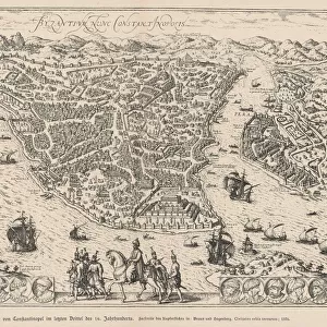
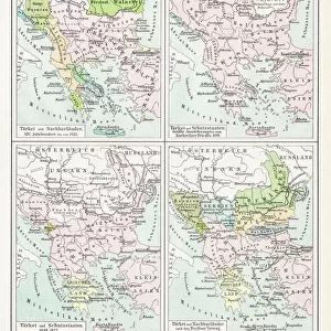
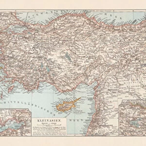
Antique map of the Turkish Empire

![]()
Wall Art and Photo Gifts from Fine Art Storehouse
Antique map of the Turkish Empire
Unleash your creativity and transform your space into a visual masterpiece!
Hemera Technologies
Media ID 13609503
© Getty Images
Arabia Black Sea Border Coordinates Data Direction Document Geography Latitude Legend Location Longitude Mediterranean Sea Middle East Place Positioning Scale Table Text Words Caspian Turkish Empire
FEATURES IN THESE COLLECTIONS
> Animals
> Insects
> Hemiptera
> Black Scale
> Europe
> Italy
> Liguria
> Imperia
> Fine Art Storehouse
> Map
> Historical Maps
> Maps and Charts
> Early Maps
EDITORS COMMENTS
This print showcases an exquisite antique map of the Turkish Empire, a true treasure from the past. With its intricate details and rich historical significance, this piece takes us on a journey through time. The carefully engraved lines depict the borders and boundaries of this vast empire, stretching from Arabia to the Black Sea and Caspian regions. The map's elegant typography reveals important coordinates, allowing us to navigate through its fascinating geography. A legend provides key information about various locations, while a scale helps us comprehend distances accurately. As we explore further, our eyes are drawn to the Mediterranean Sea and Middle East regions that were once under Turkish rule. This archival masterpiece not only documents physical geography but also captures the essence of history itself. Its vintage charm transports us back in time when empires reigned supreme and civilizations flourished. The absence of people in this image allows us to focus solely on appreciating its artistic beauty. With Hemera Technologies' expertise in photography and positioning techniques, they have flawlessly captured every minute detail with precision and clarity. This horizontal composition ensures that all elements are showcased harmoniously. Whether you're a cartography enthusiast or simply captivated by history's allure, this antique map print is sure to add elegance and intrigue to any space it graces.
MADE IN THE UK
Safe Shipping with 30 Day Money Back Guarantee
FREE PERSONALISATION*
We are proud to offer a range of customisation features including Personalised Captions, Color Filters and Picture Zoom Tools
SECURE PAYMENTS
We happily accept a wide range of payment options so you can pay for the things you need in the way that is most convenient for you
* Options may vary by product and licensing agreement. Zoomed Pictures can be adjusted in the Basket.