Home > Arts > Portraits > Animal portraiture > Fine art photography
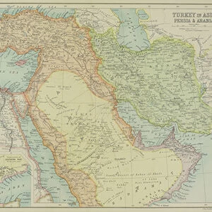
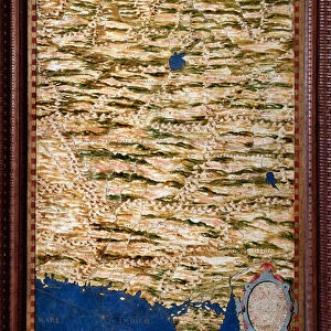
Antique map of Scythiam and Sericam with vignettes

![]()
Wall Art and Photo Gifts from Fine Art Storehouse
Antique map of Scythiam and Sericam with vignettes
Unleash your creativity and transform your space into a visual masterpiece!
Hemera Technologies
Media ID 13667367
© Getty Images
17th Century Camel Camels China Culture Direction Document Far East Geography Indigenous Culture Indigenous Peoples Kazakhstan Legend Location Mammals Nomadic People Nomads Place Positioning Russia Shelters Slovakia Tent Tents Turkmenistan Uzbekistan Vignette Vignettes Asiae China East Asia Tajikistan
FEATURES IN THESE COLLECTIONS
> Arts
> Portraits
> Animal portraiture
> Fine art photography
> Asia
> Kazakhstan
> Maps
> Asia
> Tajikistan
> Maps
> Asia
> Turkmenistan
> Related Images
> Asia
> Uzbekistan
> Maps
> Fine Art Storehouse
> Map
> Historical Maps
EDITORS COMMENTS
This 17th-century antique map of Scythiam and Sericam takes us on a journey through the rich history and diverse culture of Asia. The beautifully detailed engraving showcases the vast landscapes, indigenous peoples, and nomadic way of life that once thrived in this region. As we explore the map, our eyes are drawn to the intricate vignettes scattered throughout. These miniature scenes depict various aspects of life in Scythiam and Sericam, offering glimpses into their unique traditions and customs. From nomads traveling with their camels across the arid deserts to indigenous shelters dotting the expansive plains, each vignette tells a story waiting to be discovered. The key and legend provide valuable insights into the positioning of different territories within this historical context. We can trace our fingers along ancient trade routes that connected China with neighboring countries like Kazakhstan, Tajikistan, Turkmenistan, Uzbekistan, Russia, and Slovakia. This archival print from Hemera Technologies allows us to immerse ourselves in an era long gone by. It serves as a reminder of how geography shaped cultures while also highlighting the importance of preserving these invaluable pieces of our past. With its warm color palette and horizontal composition, this vintage photograph captures not only physical geography but also evokes a sense of wonder for those who appreciate both artistry and history.
MADE IN THE UK
Safe Shipping with 30 Day Money Back Guarantee
FREE PERSONALISATION*
We are proud to offer a range of customisation features including Personalised Captions, Color Filters and Picture Zoom Tools
SECURE PAYMENTS
We happily accept a wide range of payment options so you can pay for the things you need in the way that is most convenient for you
* Options may vary by product and licensing agreement. Zoomed Pictures can be adjusted in the Basket.