Home > Asia > Kazakhstan > Lakes > Caspian Sea
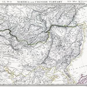
Antique map of Independent Tartary

![]()
Wall Art and Photo Gifts from Fine Art Storehouse
Antique map of Independent Tartary
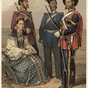
Wonderfully fine engraved map 1851 of the region of Independent Tartary, which is now the area that is Kazakhstan, Uzbekistan, Turkmenistan alongside the Caspian Sea and Aral Sea
Unleash your creativity and transform your space into a visual masterpiece!
BernardAllum
Media ID 13666887
© BernardAllum
1850 1859 66864 Aral Sea Bride Caspian Sea Frame Geographical Border Image Created 1850 1859 International Border Kazakhstan Leafy Nomadic People Tent Turkmenistan Uzbekistan Vignette Tartary
FEATURES IN THESE COLLECTIONS
> Asia
> Kazakhstan
> Lakes
> Aral Sea
> Asia
> Kazakhstan
> Lakes
> Caspian Sea
> Asia
> Kazakhstan
> Maps
> Asia
> Turkmenistan
> Related Images
> Asia
> Uzbekistan
> Lakes
> Aral Sea
> Asia
> Uzbekistan
> Maps
> Fine Art Storehouse
> Map
> Historical Maps
> Maps and Charts
> Early Maps
> Maps and Charts
> Kazakhstan
EDITORS COMMENTS
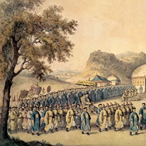
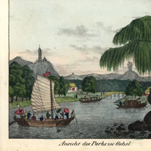
This beautifully preserved antique map of Independent Tartary takes us back to the year 1851, offering a glimpse into the rich history and cultural heritage of the region. Engraved with utmost precision and attention to detail, this wonderous piece showcases the vast expanse that is now known as Kazakhstan, Uzbekistan, and Turkmenistan. Nestled alongside the Caspian Sea and Aral Sea, these lands were once home to nomadic people who roamed freely under leafy canopies. The image captures more than just geographical borders; it paints a vivid picture of local customs and traditions. In one corner, an entertainment tent stands tall, inviting passersby to revel in its festivities. A bride adorned in traditional attire adds a touch of elegance to this vibrant scene. As we delve deeper into this historical masterpiece created between 1850-1859 by Bernard Allum, color illustrations transport us back in time. The intricate frame surrounding the map serves as a testament to its significance as both an artistic creation and a valuable source of knowledge. Let this print take you on a journey through time - exploring ancient trade routes, discovering hidden treasures within each engraved vignette. It serves not only as a decorative piece but also as a reminder of our ever-evolving world's fascinating past.
MADE IN THE UK
Safe Shipping with 30 Day Money Back Guarantee
FREE PERSONALISATION*
We are proud to offer a range of customisation features including Personalised Captions, Color Filters and Picture Zoom Tools
SECURE PAYMENTS
We happily accept a wide range of payment options so you can pay for the things you need in the way that is most convenient for you
* Options may vary by product and licensing agreement. Zoomed Pictures can be adjusted in the Basket.