Home > Asia > Saudi Arabia > Maps
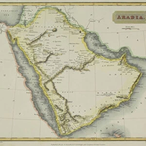
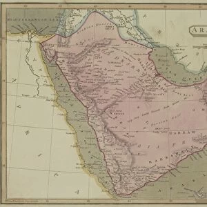
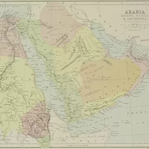
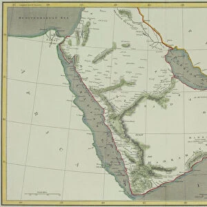
Antique map of Arabia with the Red Sea and Persian Gulf

![]()
Wall Art and Photo Gifts from Fine Art Storehouse
Antique map of Arabia with the Red Sea and Persian Gulf
Unleash your creativity and transform your space into a visual masterpiece!
Hemera Technologies
Media ID 13667365
© Getty Images
Arabia Arabian Peninsula Direction Document Egypt Geography Indian Ocean Iran Iraq Latitude Legend Location Longitude Middle East Persia Persian Gulf Place Positioning Red Sea Saudi Arabia Title
FEATURES IN THESE COLLECTIONS
> Asia
> Saudi Arabia
> Maps
> Fine Art Storehouse
> Map
> Historical Maps
> Maps and Charts
> Early Maps
EDITORS COMMENTS
This print showcases an exquisite antique map of Arabia, featuring the mesmerizing Red Sea and Persian Gulf. Crafted with meticulous detail and precision, this archival piece takes us on a journey through time, offering a glimpse into the rich history and geography of the Arabian Peninsula. The intricate engravings depict various key locations such as Egypt, Iraq, Iran, Saudi Arabia, and Persia. The map's elegant design is complemented by a carefully crafted legend that guides us in understanding its physical features. With latitude and longitude lines guiding our way, we can almost feel ourselves transported to this ancient land. As we immerse ourselves in this vintage masterpiece, it becomes evident that it holds immense historical significance. It serves as both a document of past cartography techniques and a testament to the exploratory spirit of early civilizations. Its presence evokes curiosity about the trade routes that once thrived along these shores while reminding us of the region's pivotal role in shaping world history. Photographed horizontally with vibrant colors accentuating its beauty, this print captures every intricate detail for all to admire. In this image devoid of people or modern interference lies an invitation to explore not only geographical landscapes but also our own fascination with history itself.
MADE IN THE UK
Safe Shipping with 30 Day Money Back Guarantee
FREE PERSONALISATION*
We are proud to offer a range of customisation features including Personalised Captions, Color Filters and Picture Zoom Tools
SECURE PAYMENTS
We happily accept a wide range of payment options so you can pay for the things you need in the way that is most convenient for you
* Options may vary by product and licensing agreement. Zoomed Pictures can be adjusted in the Basket.