Home > Africa > Ethiopia (Abyssinia) > Maps
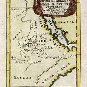
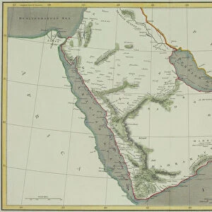
Antique map of Arabia with Egypt, Nubia, and Abyssinia

![]()
Wall Art and Photo Gifts from Fine Art Storehouse
Antique map of Arabia with Egypt, Nubia, and Abyssinia
Unleash your creativity and transform your space into a visual masterpiece!
Hemera Technologies
Media ID 13609459
© Getty Images
Abyssinia Arabian Peninsula Border Direction Document Egypt Ethiopia Geography Horn Of Africa Indian Ocean Iran Latitude Legend Location Longitude Middle East Nubia Persia Persian Gulf Place Positioning Red Sea Saudi Arabia Scale
FEATURES IN THESE COLLECTIONS
> Africa
> Ethiopia (Abyssinia)
> Maps
> Africa
> Ethiopia
> Related Images
> Asia
> Saudi Arabia
> Maps
> Fine Art Storehouse
> Map
> Historical Maps
> Maps and Charts
> Early Maps
EDITORS COMMENTS
This antique map of Arabia with Egypt, Nubia, and Abyssinia takes us on a journey through time. Crafted by Hemera Technologies, this archival print showcases the intricate details of cartography from a bygone era. The rich history and cultural significance of the Arabian Peninsula are beautifully depicted in this vintage piece. The map highlights key locations such as Saudi Arabia, Iran, Ethiopia, and the Horn of Africa. It provides an invaluable glimpse into the physical geography of the region, showcasing borders, latitude lines, longitude markers, and even a scale for measurement. The Red Sea and Persian Gulf stand out prominently as important waterways that have shaped trade routes throughout history. Engraved with precision and attention to detail, this historic document offers more than just geographical information; it tells stories of ancient civilizations that once thrived in these lands. As we gaze upon this color image without any people present in it, we can't help but imagine the bustling markets along the coastlines or camel caravans traversing vast deserts. Whether you're a lover of history or simply appreciate fine art photography like this one from Fine Art Storehouse's collection - "Antique map of Arabia with Egypt" is sure to captivate your imagination and transport you back in time to an era where exploration was at its peak.
MADE IN THE UK
Safe Shipping with 30 Day Money Back Guarantee
FREE PERSONALISATION*
We are proud to offer a range of customisation features including Personalised Captions, Color Filters and Picture Zoom Tools
SECURE PAYMENTS
We happily accept a wide range of payment options so you can pay for the things you need in the way that is most convenient for you
* Options may vary by product and licensing agreement. Zoomed Pictures can be adjusted in the Basket.