Home > North America > United States of America > Maps
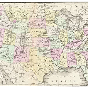
United States North East Central map 1897

![]()
Wall Art and Photo Gifts from Fine Art Storehouse
United States North East Central map 1897
The World-Wide Atlas of Modern Geography, Political and Physical W. & A.K. Johnston - London 1897
Unleash your creativity and transform your space into a visual masterpiece!
THEPALMER
Media ID 14457421
© Roberto A Sanchez
Atlas Country Geographic Area Earth Indiana Kentucky North Carolina Ohio Paper Pennsylvania Sepia Toned Tennessee Textured Effect World Map Retro Styled
FEATURES IN THESE COLLECTIONS
> Europe
> United Kingdom
> England
> London
> Related Images
> Fine Art Storehouse
> Map
> Historical Maps
> Fine Art Storehouse
> Map
> USA Maps
> Maps and Charts
> Early Maps
> Maps and Charts
> World
> North America
> United States of America
> Indiana
> Related Images
> North America
> United States of America
> Kentucky
> Related Images
> North America
> United States of America
> Maps
> North America
> United States of America
> North Carolina
> Related Images
> North America
> United States of America
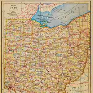
> Ohio
> Related Images
> North America
> United States of America
> Pennsylvania
> Related Images
EDITORS COMMENTS
This print takes us back in time to the year 1897, showcasing a beautifully detailed map of the United States' North East Central region. The vintage charm of this piece is evident through its retro styling and antique appeal. Published in London by W. & A. K. Johnston as part of "The World-Wide Atlas of Modern Geography, Political and Physical" this engraving exudes a sense of history and exploration. The intricate cartography on display here offers a glimpse into the past, highlighting states such as Ohio, Indiana, Pennsylvania, North Carolina, Tennessee, and Kentucky. Each boundary line is meticulously engraved onto the paper with precision and care. The textured effect adds depth to the image while giving it an aged appearance that further enhances its nostalgic allure. Sepia-toned hues lend warmth to the overall composition, evoking a sense of nostalgia for simpler times. As we gaze upon this remarkable piece from THEPALMER collection at Fine Art Storehouse, we are reminded of how geography has shaped our world throughout centuries. This map serves as both an educational tool and a work of art—an embodiment of human curiosity about our planet's vastness. Whether you're a history enthusiast or simply appreciate fine craftsmanship, this print will transport you back in time to explore America's rich geographic heritage within its borders—capturing your imagination with every glance.
MADE IN THE UK
Safe Shipping with 30 Day Money Back Guarantee
FREE PERSONALISATION*
We are proud to offer a range of customisation features including Personalised Captions, Color Filters and Picture Zoom Tools
SECURE PAYMENTS
We happily accept a wide range of payment options so you can pay for the things you need in the way that is most convenient for you
* Options may vary by product and licensing agreement. Zoomed Pictures can be adjusted in the Basket.