Home > Asia > Georgia > Maps
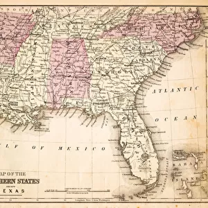
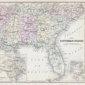
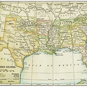
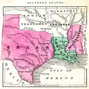
Map of Southern States USA 1895

![]()
Wall Art and Photo Gifts from Fine Art Storehouse
Map of Southern States USA 1895
The Rand-McNally Grammar School Geography 1895 - Chicago & New York
Unleash your creativity and transform your space into a visual masterpiece!
THEPALMER
Media ID 14824611
© This content is subject to copyright
Alabama Arkansas Florida Georgia Louisiana Mississippi North Carolina South Carolina Tennessee
FEATURES IN THESE COLLECTIONS
> Fine Art Storehouse
> Map
> Historical Maps
> Fine Art Storehouse
> Map
> USA Maps
> USA Southern States Historical Maps
> Fine Art Storehouse
> Map
> USA Maps
> Maps and Charts
> Early Maps
> North America
> United States of America
> Alabama
> Related Images
> North America
> United States of America
> Arkansas
> Related Images
> North America
> United States of America
> Florida
> Related Images
> North America
> United States of America
> Georgia
> Related Images
> North America
> United States of America
> Louisiana
> Related Images
> North America
> United States of America
> Maps
> North America
> United States of America
> Mississippi
> Related Images
EDITORS COMMENTS
In this print titled "Map of Southern States USA 1895" we are transported back in time to the late 19th century, where geography was taught through beautifully detailed maps. The image showcases a vintage map from "The Rand-McNally Grammar School Geography 1895 - Chicago & New York" publication, specifically focusing on the southern states of Mississippi, Alabama, Arkansas, Florida, Georgia, Louisiana, North Carolina, South Carolina, and Tennessee. As we delve into this historical piece by THEPALMER from Fine Art Storehouse, we can't help but be mesmerized by the intricate details and craftsmanship that went into creating such a comprehensive map. Every river is meticulously drawn; every city and town carefully labeled. It serves as a testament to the dedication and precision of cartographers during that era. This particular print offers us an opportunity to explore the past and gain insight into how these southern states were perceived over a century ago. It allows us to reflect on their rich history and cultural heritage while appreciating the advancements made since then. Whether you're an avid collector or simply fascinated by history's unfolding storylines captured in art form, this photograph print is sure to spark curiosity and ignite conversations about our ever-evolving world. Let it transport you back in time as you marvel at its beauty while contemplating how far we've come since those days depicted on this remarkable map.
MADE IN THE UK
Safe Shipping with 30 Day Money Back Guarantee
FREE PERSONALISATION*
We are proud to offer a range of customisation features including Personalised Captions, Color Filters and Picture Zoom Tools
SECURE PAYMENTS
We happily accept a wide range of payment options so you can pay for the things you need in the way that is most convenient for you
* Options may vary by product and licensing agreement. Zoomed Pictures can be adjusted in the Basket.