Home > Europe > Serbia > Maps
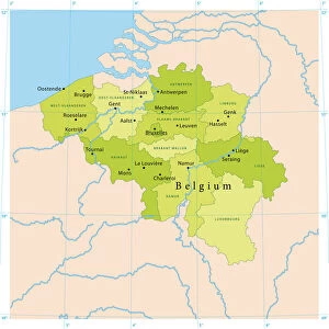
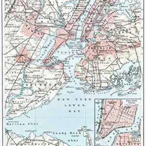
Brussels map

![]()
Wall Art and Photo Gifts from Fine Art Storehouse
Brussels map
Illustration of a Brussels map
Unleash your creativity and transform your space into a visual masterpiece!
Nastasic
Media ID 13750703
© This content is subject to copyright
Belgium Benelux Brussels Capital Region City Map Flanders Belgium Image Date Serbia
FEATURES IN THESE COLLECTIONS
> Fine Art Storehouse
> Map
> Historical Maps
> Maps and Charts
> Early Maps
EDITORS COMMENTS
This print showcases an exquisite illustration of a Brussels map, taking us back in time to the 19th century. The intricate details and delicate lines of this engraving are truly mesmerizing, capturing the essence of cartography as both an art form and a historical record. The Brussels map depicted here is not just a geographical representation but also a window into the rich history and cultural significance of Belgium's capital city. From its position within the Benelux region to its connection with Flanders, this map provides valuable insights into the geopolitical landscape of Europe during that era. The artist behind this remarkable piece is Nastasic, whose skillful use of illustration techniques such as woodcut and etching brings depth and character to every stroke. The result is a visually stunning engraved image that transports viewers through time. Whether you have an affinity for maps or simply appreciate fine art, this vertical print will undoubtedly make a striking addition to any space. Its timeless charm serves as a reminder of how our world has evolved over centuries while preserving traces of our past.
MADE IN THE UK
Safe Shipping with 30 Day Money Back Guarantee
FREE PERSONALISATION*
We are proud to offer a range of customisation features including Personalised Captions, Color Filters and Picture Zoom Tools
SECURE PAYMENTS
We happily accept a wide range of payment options so you can pay for the things you need in the way that is most convenient for you
* Options may vary by product and licensing agreement. Zoomed Pictures can be adjusted in the Basket.