Home > Europe > Iceland > Maps
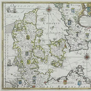
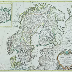
Antique map of Scandinavian region with Iceland and Greenland

![]()
Wall Art and Photo Gifts from Fine Art Storehouse
Antique map of Scandinavian region with Iceland and Greenland
Unleash your creativity and transform your space into a visual masterpiece!
Hemera Technologies
Media ID 13597663
© Getty Images
Atlantic Ocean British Isles Canada Concentric Countries Denmark Document Finland Flag Geographical Locations Geography Great Britain Greenland Iceland Legend Line Lines Longitude Nations North Sea Norway Norwegian Sea Patriotism Pole Region Scandinavian Sweden Baffin Bay Radiating
FEATURES IN THESE COLLECTIONS
> Europe
> United Kingdom
> Maps
> Fine Art Storehouse
> Map
> Denmark Maps
> Fine Art Storehouse
> Map
> Historical Maps
> Maps and Charts
> Early Maps
EDITORS COMMENTS
This antique print showcases a beautifully detailed map of the Scandinavian region, including Iceland and Greenland. A true testament to the artistry of cartography, this archival piece takes us back in time to explore the geography and history of these northern lands. The map features intricate lines radiating from a central point, indicating longitude and key geographical locations. With its vibrant colors and horizontal composition, this vintage print captures the essence of Scandinavia's rich heritage. From Norway's majestic fjords to Sweden's picturesque landscapes, every nation is meticulously depicted with their respective flags proudly displayed. The British Isles can also be seen on this map as well as Baffin Bay in Canada. As we delve into this historical document, our eyes are drawn towards the vast Atlantic Ocean and Norwegian Sea that surround these nations. The presence of Greenland adds an extra layer of intrigue to this piece, reminding us of its significance within Arctic exploration. Whether you are a history enthusiast or simply appreciate fine photography, this antique map will transport you back in time while igniting your sense of adventure. Its physical beauty combined with its patriotic undertones make it a perfect addition to any collection or display space. Let yourself get lost in the enchanting world captured by Hemera Technologies' masterful creation!
MADE IN THE UK
Safe Shipping with 30 Day Money Back Guarantee
FREE PERSONALISATION*
We are proud to offer a range of customisation features including Personalised Captions, Color Filters and Picture Zoom Tools
SECURE PAYMENTS
We happily accept a wide range of payment options so you can pay for the things you need in the way that is most convenient for you
* Options may vary by product and licensing agreement. Zoomed Pictures can be adjusted in the Basket.