Home > Oceania > Australia > Maps
africa, animals, antique, archival, art, asia, australia, border, cartography, continents

![]()
Wall Art and Photo Gifts from Fine Art Storehouse
africa, animals, antique, archival, art, asia, australia, border, cartography, continents
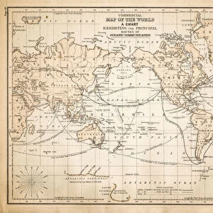
africa, animals, antique, archival, art, asia, australia, border, cartography, continents, culture, decorative, depicted, depicting, depiction, diversity, document, eastern hemisphere, europe, explorers, figures, geography, globe, historic, historical, indigenous peoples, insets, interracial, map, missionaries, natives, old world, text, title, vintage, words, Antique Maps, 87635767
Unleash your creativity and transform your space into a visual masterpiece!
Hemera Technologies
Media ID 14761284
© Getty Images
Australia Border Continents Culture Decorative Depicted Depicting Diversity Document Eastern Hemisphere Explorers Figures Geography Globe Indigenous Peoples Natives Old World Text Title Words Insets Interracial Missionaries
FEATURES IN THESE COLLECTIONS
> Africa
> Related Images
> Asia
> Related Images
> Europe
> Related Images
> Fine Art Storehouse
> Map
> Historical Maps
> Maps and Charts
> Early Maps
> Maps and Charts
> World
EDITORS COMMENTS
This print by Hemera Technologies takes us on a journey through time and space, capturing the essence of Africa's rich diversity and cultural heritage. The antique map, with its intricate cartography and decorative border, transports us to an era when explorers ventured into uncharted territories. Depicting the continents of Africa, Asia, Australia, and Europe in stunning detail, this archival artwork offers a glimpse into the historical significance of these regions. The figures of indigenous peoples and missionaries scattered across the map remind us of the complex interactions between different cultures during that period. The inclusion of animals adds an element of wonder to this vintage piece. From majestic elephants roaming African plains to exotic species found in Asia and Australia, these creatures symbolize both the natural beauty and untamed wilderness that once defined these lands. As we explore each inset on this old-world globe, we are reminded of how far humanity has come in understanding our planet's geography. This document serves as a testament to the curiosity and determination exhibited by early explorers who sought to uncover new horizons. With its historic charm preserved through meticulous restoration work, this art print is not only visually striking but also serves as a valuable educational resource for those interested in studying past civilizations. Whether displayed in homes or institutions dedicated to preserving history's wonders, this antique map invites viewers to embark on their own voyage through time.
MADE IN THE UK
Safe Shipping with 30 Day Money Back Guarantee
FREE PERSONALISATION*
We are proud to offer a range of customisation features including Personalised Captions, Color Filters and Picture Zoom Tools
SECURE PAYMENTS
We happily accept a wide range of payment options so you can pay for the things you need in the way that is most convenient for you
* Options may vary by product and licensing agreement. Zoomed Pictures can be adjusted in the Basket.