Home > Maps and Charts > Early Maps
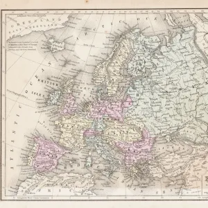
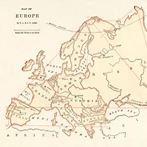
Map of Europe 1868

![]()
Wall Art and Photo Gifts from Fine Art Storehouse
Map of Europe 1868
Guyots The Earth Common School Geography - 1868
Unleash your creativity and transform your space into a visual masterpiece!
THEPALMER
Media ID 19834461
© 2014 Roberto Adrian Photography
FEATURES IN THESE COLLECTIONS
> Europe
> Related Images
> Fine Art Storehouse
> Map
> Historical Maps
> Maps and Charts
> Early Maps
EDITORS COMMENTS
This print showcases a remarkable piece of history, the "Map of Europe 1868" from Guyots The Earth Common School Geography. With its intricate details and vintage charm, this artwork takes us on a visual journey back to the year 1868 when Europe was undergoing significant transformations. The map's delicate lines and faded colors tell tales of a bygone era, where borders shifted and nations evolved. It offers an intriguing glimpse into the political landscape of that time, capturing the essence of European geography as it stood over a century ago. As we gaze upon this mesmerizing print by THEPALMER from Fine Art Storehouse, our imagination is ignited with thoughts of explorers embarking on grand adventures across these lands. We envision diplomats negotiating treaties and historians chronicling events that shaped our world today. Beyond its historical significance, this artwork also serves as a testament to human curiosity and progress in cartography. It reminds us how far we have come in understanding our planet's intricacies while honoring those who paved the way for modern geographical knowledge. Whether displayed in an educational setting or cherished within one's personal collection, this Map of Europe 1868 print invites viewers to appreciate both artistry and academia intertwined seamlessly together. Its timeless appeal resonates with enthusiasts seeking to connect with past eras while celebrating the beauty found within antique maps like this one.
MADE IN THE UK
Safe Shipping with 30 Day Money Back Guarantee
FREE PERSONALISATION*
We are proud to offer a range of customisation features including Personalised Captions, Color Filters and Picture Zoom Tools
SECURE PAYMENTS
We happily accept a wide range of payment options so you can pay for the things you need in the way that is most convenient for you
* Options may vary by product and licensing agreement. Zoomed Pictures can be adjusted in the Basket.