Home > Africa > Sudan > Maps
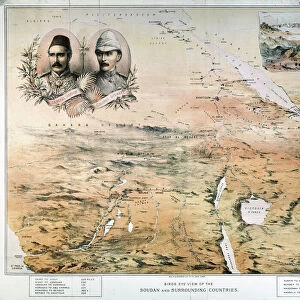
Map of Egypt, Nile Delta and Sudan, lithograph, published 1893

![]()
Wall Art and Photo Gifts from Fine Art Storehouse
Map of Egypt, Nile Delta and Sudan, lithograph, published 1893
Historical map of Egypt, Nile Delta and Sudan. Description in German. Lithograph, published in 1893
Unleash your creativity and transform your space into a visual masterpiece!
ZU_09
Media ID 35842634
FEATURES IN THESE COLLECTIONS
> Fine Art Storehouse
> Map
> Historical Maps
> Maps and Charts
> Early Maps
EDITORS COMMENTS
This lithograph showcases a historical map of Egypt, Nile Delta, and Sudan, published in the year 1893. The intricate detail and precision of the image transport us back in time, offering a glimpse into the geographical knowledge of the late 19th century. The map covers a vast area, extending from the Mediterranean Sea in the north to the Third Cataract of the Nile in the south. The Nile River, the lifeblood of the region, meanders through the map, its delta spreading out in a complex network of branches and tributaries. To the west, the Western Desert stretches out, a vast expanse of sand and dunes, while to the east lies the Red Sea. The Sahara Desert, a formidable barrier, is depicted in the southwestern corner of the map. Several key cities and landmarks are labeled, including Alexandria, Cairo, Aswan, and the Great Pyramids of Giza. Sudan, then part of the Egyptian Empire, is also shown in its entirety, with the major Nubian kingdoms of Meroe and Napata highlighted. The map is adorned with an elegant border, featuring intricate floral and geometric designs. The title, "Aegypten, Nildelta und Sudan," is inscribed in the top left corner, with the publication date, "1893," below. This historical map offers a fascinating glimpse into the geography and cartography of the late 19th century, providing valuable context for the study of ancient civilizations and the exploration of the African continent.
MADE IN THE UK
Safe Shipping with 30 Day Money Back Guarantee
FREE PERSONALISATION*
We are proud to offer a range of customisation features including Personalised Captions, Color Filters and Picture Zoom Tools
SECURE PAYMENTS
We happily accept a wide range of payment options so you can pay for the things you need in the way that is most convenient for you
* Options may vary by product and licensing agreement. Zoomed Pictures can be adjusted in the Basket.