Home > Maps and Charts > Africa
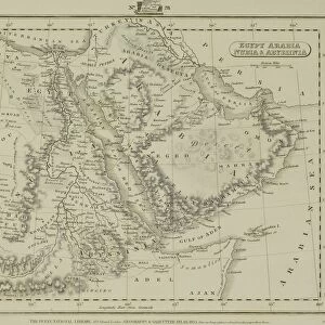
Antique map of Ancient North Africa, Atlas of Ancient Geography

![]()
Wall Art and Photo Gifts from Fine Art Storehouse
Antique map of Ancient North Africa, Atlas of Ancient Geography
Vintage illustration of Antique map of Ancient North Africa, Atlas of Ancient Geography. By Samuel Butler
Unleash your creativity and transform your space into a visual masterpiece!
duncan1890
Media ID 25600713
FEATURES IN THESE COLLECTIONS
> Africa
> Related Images
> Fine Art Storehouse
> Map
> Historical Maps
> Maps and Charts
> Early Maps
EDITORS COMMENTS
This print showcases an exquisite antique map of Ancient North Africa, taken from the renowned Atlas of Ancient Geography. Crafted by the talented Samuel Butler, this vintage illustration takes us on a journey through time, unraveling the mysteries and allure of this ancient land. The intricate details and delicate craftsmanship evident in this piece transport us back to a bygone era. Every contour and feature is meticulously depicted, allowing us to explore the vast expanse of North Africa as it once was. From the majestic Nile River snaking its way through Egypt to the rugged mountains dotting Morocco's landscape, every element tells a story waiting to be discovered. As we gaze upon this remarkable work of art, we are reminded of how geography played a pivotal role in shaping civilizations throughout history. The accuracy and precision with which Butler captures these geographical nuances serve as a testament to his skill as both an artist and cartographer. This print from Fine Art Storehouse allows us to bring home a piece of history, inviting us into our own personal exploration of Ancient North Africa. Whether displayed in our study or living room, it serves as a constant reminder that beneath our modern world lies layers upon layers of rich heritage just waiting to be uncovered.
MADE IN THE UK
Safe Shipping with 30 Day Money Back Guarantee
FREE PERSONALISATION*
We are proud to offer a range of customisation features including Personalised Captions, Color Filters and Picture Zoom Tools
SECURE PAYMENTS
We happily accept a wide range of payment options so you can pay for the things you need in the way that is most convenient for you
* Options may vary by product and licensing agreement. Zoomed Pictures can be adjusted in the Basket.