Home > Africa > Madagascar > Maps
Main research trips in Africa 1895

![]()
Wall Art and Photo Gifts from Fine Art Storehouse
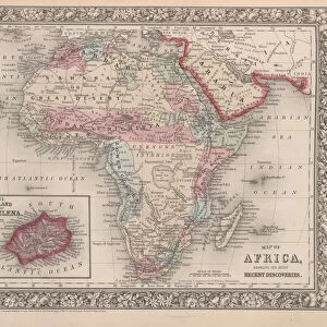
Main research trips in Africa 1895
Meyers Konversations-Lexikon. Ein Nachschlagewerk des allgemeinen Wissens, 5th edition 17 volumes Bibliographisches Institut - Leipzig 1895-1897
Unleash your creativity and transform your space into a visual masterpiece!
THEPALMER
Media ID 13611763
© This content is subject to copyright
Algeria Atlas Mythological Figure Central Africa East Africa Egypt Exploration Journey Madagascar Middle East Morocco North Africa Paper Politics Politics And Government Research Sahara Desert World Map
FEATURES IN THESE COLLECTIONS
> Africa
> Madagascar
> Maps
> Fine Art Storehouse
> The Magical World of Illustration
> Palmer Illustrated Collection
> Fine Art Storehouse
> Map
> Historical Maps
> Fine Art Storehouse
> Map
> USA Maps
> Fine Art Storehouse
> Travel Imagery
> Travel Destinations
> Morocco, North Africa
> Fine Art Storehouse
> Ultimate Earth Prints
> Amazing Deserts
> Maps and Charts
> Early Maps
> Maps and Charts
> World
> North America
> United States of America
> Maps
EDITORS COMMENTS
This print titled "Main research trips in Africa 1895" takes us on a mesmerizing journey through time and space. With its origins dating back to the late 19th century, this image is an engraved illustration from Meyers Konversations-Lexikon, a renowned encyclopedia of general knowledge. The vertical composition showcases an intricate world map, meticulously crafted by skilled cartographers of that era. It highlights the vastness and diversity of Africa's landscapes, as well as key regions such as Madagascar, Egypt, North Africa, East Africa, Morocco, Central Africa, Algeria, and even parts of the Sahara Desert. As we delve into this antique piece of artistry and exploration, it becomes evident that it represents more than just physical geography. The inclusion of political boundaries suggests a deeper understanding of politics and government during that period. This print serves as a visual testament to the extensive research conducted by intrepid explorers who ventured into uncharted territories across continents. It offers us a glimpse into their tireless efforts to expand our knowledge about distant lands. With its rich historical significance and exquisite craftsmanship captured in paper form through engraving techniques prevalent at the time; this artwork holds immense value for collectors or enthusiasts interested in both art history and geographical discovery. THEPALMER has skillfully preserved this treasure from yesteryears for us to appreciate today.
MADE IN THE UK
Safe Shipping with 30 Day Money Back Guarantee
FREE PERSONALISATION*
We are proud to offer a range of customisation features including Personalised Captions, Color Filters and Picture Zoom Tools
SECURE PAYMENTS
We happily accept a wide range of payment options so you can pay for the things you need in the way that is most convenient for you
* Options may vary by product and licensing agreement. Zoomed Pictures can be adjusted in the Basket.