Home > Africa > Algeria > Maps
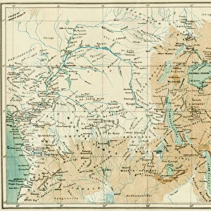
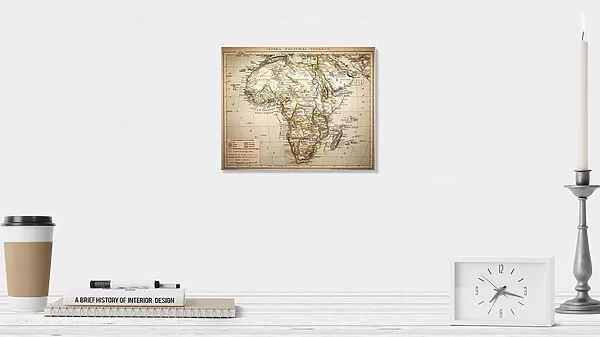
Photographic Print : Africa Political Map


![]()
Photo Prints from Fine Art Storehouse
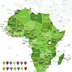
Africa Political Map
Antique illustration of a Africa Political Map from 1893
Unleash your creativity and transform your space into a visual masterpiece!
Nastasic
Media ID 13591693
© Nikola Nastasic
1893 Algeria Angola Botswana Boundary Cameroon Continent Egypt Ethiopia Gabon Gambia Ghana Guinea Horn Of Africa Kenya Lesotho Libya Madagascar Malawi Mali Middle East Morocco Mozambique Niger Politics Politics And Government Somalia Sudan Tanzania Tunisia Uganda Zambia Zimbabwe Benin Burundi Chad Comoros Djibouti Eritrea Liberia Mauritania Nigeria Republic Of The Congo Senegal
10"x8" (25x20cm) Photo Print
Discover the captivating allure of the past with our "Africa Political Map" print from Nastasic, exclusively available in the Media Storehouse Fine Art collection. This intriguing antique illustration, originally created in 1893, offers a fascinating glimpse into the political landscape of Africa during a pivotal period in its history. With intricate detail and vivid colors, this print makes a striking addition to any space, transporting you on a journey through time. Bring history into your home or office, and start a conversation with this unique and thought-provoking piece. Order your "Africa Political Map" print today from Media Storehouse Fine Art.
Printed on archival quality paper for unrivalled stable artwork permanence and brilliant colour reproduction with accurate colour rendition and smooth tones. Printed on professional 234gsm Fujifilm Crystal Archive DP II paper. 10x8 for landscape images, 8x10 for portrait images.
Our Photo Prints are in a large range of sizes and are printed on Archival Quality Paper for excellent colour reproduction and longevity. They are ideal for framing (our Framed Prints use these) at a reasonable cost. Alternatives include cheaper Poster Prints and higher quality Fine Art Paper, the choice of which is largely dependant on your budget.
Estimated Product Size is 25.4cm x 20.3cm (10" x 8")
These are individually made so all sizes are approximate
Artwork printed orientated as per the preview above, with landscape (horizontal) orientation to match the source image.
FEATURES IN THESE COLLECTIONS
> Africa
> Algeria
> Related Images
> Africa
> Angola
> Related Images
> Africa
> Benin
> Related Images
> Africa
> Botswana
> Related Images
> Africa
> Burundi
> Related Images
> Fine Art Storehouse
> The Magical World of Illustration
> Nastasic Images & Illustrations
> Fine Art Storehouse
> Map
> Historical Maps
> Fine Art Storehouse
> Travel Imagery
> Travel Destinations
> Morocco, North Africa
EDITORS COMMENTS
This print showcases an antique illustration of an Africa Political Map from 1893. The intricately engraved image takes us on a journey through the continent's rich history and diverse geography. From the northernmost point of Egypt to the southern tip of South Africa, this map encompasses the vastness and complexity of Africa. The map highlights various countries including Burundi, Lesotho, Zimbabwe, Zambia, Mozambique, Malawi, Botswana, Angola, Madagascar, Uganda, Tanzania, Sudan, Somalia Kenya Ethiopia Eritrea Djibouti Gabon Republic of Congo Chad Cameroon Senegal Nigeria Niger Mauritania Mali Liberia Guinea Ghana Benin Gambia Tunisia Morocco Libya Algeria Comoros. Each boundary is meticulously drawn with precision and attention to detail. As we explore this vintage masterpiece further; it not only provides insight into physical geography but also offers a glimpse into African politics and government during that era. It serves as a reminder of how borders have shifted over time and how nations have evolved politically. This horizontal composition captures the essence of Africa's cultural heritage by showcasing its capital cities along with key landmarks throughout the continent. The Middle East and Horn of Africa are also depicted in this comprehensive representation. Nastasic has expertly preserved this historical treasure for us to appreciate today. This print transports us back in time while reminding us of the enduring beauty and significance that lies within Africa's past.
MADE IN THE UK
Safe Shipping with 30 Day Money Back Guarantee
FREE PERSONALISATION*
We are proud to offer a range of customisation features including Personalised Captions, Color Filters and Picture Zoom Tools
SECURE PAYMENTS
We happily accept a wide range of payment options so you can pay for the things you need in the way that is most convenient for you
* Options may vary by product and licensing agreement. Zoomed Pictures can be adjusted in the Basket.