Home > Africa > Eritrea > Maps
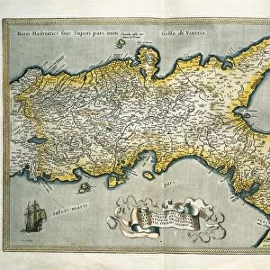
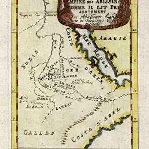
Abyssinia, Eritrea and South Arabia

![]()
Wall Art and Photo Gifts from Fine Art Storehouse
Abyssinia, Eritrea and South Arabia
Antique illustration of a Abyssinia, Eritrea and South Arabia
Unleash your creativity and transform your space into a visual masterpiece!
Nastasic
Media ID 13590355
© This content is subject to copyright
Arabia Bay Of Water Country Geographic Area Egypt Ethiopia Geographical Border Geographical Locations Horn Of Africa International Border Iran Iraq Jordan Middle East Kuwait Land Light Natural Phenomenon Middle East Middle Eastern Ethnicity Oman Outline Peninsula Persian Gulf Persian Gulf Countries Politics Politics And Government Red Sea Saudi Arabia Serbia Sudan United Arab Emirates Bahrain Eritrea Multi Colored Riyadh
FEATURES IN THESE COLLECTIONS
> Africa
> Ethiopia (Abyssinia)
> Maps
> Africa
> Ethiopia
> Related Images
> Africa
> Sudan
> Related Images
> Fine Art Storehouse
> The Magical World of Illustration
> Nastasic Images & Illustrations
> Fine Art Storehouse
> Map
> Historical Maps
EDITORS COMMENTS
This antique illustration takes us on a journey through the enchanting lands of Abyssinia, Eritrea, and South Arabia. The print showcases the intricate details of these geographical locations, with their diverse landscapes and rich cultural heritage. In this horizontal composition, we see a woman of Middle Eastern ethnicity gazing at the map with curiosity and wonder. Her presence adds depth to the image as she represents the people who have inhabited these regions for centuries. The artist's skillful use of engraving brings out every contour and border in this stunning piece. The outline technique beautifully highlights each country's geographic area while emphasizing their international borders. The vibrant colors used in this illustration evoke a sense of liveliness and energy. Shades of blue symbolize the surrounding bodies of water such as the Red Sea and Persian Gulf, while touches of red add warmth to land areas. As we explore this artwork further, our eyes are drawn to key landmarks like Riyadh in Saudi Arabia or Kuwait City in Kuwait. These cities serve as reminders that politics play an essential role in shaping these nations' history. Overall, Nastasic's print captures not only the physical aspects but also hints at political dynamics within these regions. It serves as both a decorative piece for any space and an educational tool that sparks curiosity about different cultures around the world.
MADE IN THE UK
Safe Shipping with 30 Day Money Back Guarantee
FREE PERSONALISATION*
We are proud to offer a range of customisation features including Personalised Captions, Color Filters and Picture Zoom Tools
SECURE PAYMENTS
We happily accept a wide range of payment options so you can pay for the things you need in the way that is most convenient for you
* Options may vary by product and licensing agreement. Zoomed Pictures can be adjusted in the Basket.