Home > North America > United States of America > New York > New York > Maps
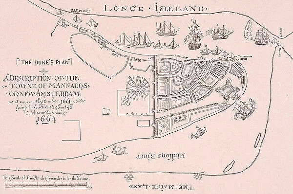
Longe Iseland Map
![]()

Wall Art and Photo Gifts from Fine Art Storehouse
Longe Iseland Map
A map of Long Island, New York, 1664. Known as The Dukes Plan, it depicts a plan for the Towne of Mannados or New Amsterdam. (Photo by Archive Photos/Getty Images)
Unleash your creativity and transform your space into a visual masterpiece!
Archive Photos
Media ID 11925978
© 2005 Getty Images
FEATURES IN THESE COLLECTIONS
> Architecture
> Country
> America
> North America
> United States of America
> New York
> New York
> Maps
EDITORS COMMENTS
This print showcases a historical treasure, the "Long Island Map" from 1664. Known as The Dukes Plan, this meticulously detailed map depicts the Towne of Mannados or New Amsterdam in Long Island, New York. Preserved through time and now brought to life by Archive Photos/Getty Images, this piece offers a glimpse into the early days of North America's architectural landscape. The intricate lines and delicate strokes on this map highlight the skill and artistry involved in its creation. Every corner is filled with rich information about the land, settlements, and waterways that once shaped Long Island's history. As we gaze upon it today, we are transported back to an era when exploration was at its peak. This photograph captures not only a visual representation but also an essence of nostalgia for those who appreciate historical artifacts. It serves as a reminder of how much has changed over centuries while honoring our roots and heritage. Archive Photos' dedication to preserving such valuable pieces allows us to connect with our past in ways that words alone cannot convey. This print invites us to immerse ourselves in history's embrace and encourages further exploration into the fascinating stories behind each stroke on this remarkable map. Whether displayed proudly on your wall or admired within private collections, this extraordinary image will undoubtedly spark conversations about our collective journey through time.
MADE IN THE UK
Safe Shipping with 30 Day Money Back Guarantee
FREE PERSONALISATION*
We are proud to offer a range of customisation features including Personalised Captions, Color Filters and Picture Zoom Tools
SECURE PAYMENTS
We happily accept a wide range of payment options so you can pay for the things you need in the way that is most convenient for you
* Options may vary by product and licensing agreement. Zoomed Pictures can be adjusted in the Basket.


