Home > Europe > Russia > Maps
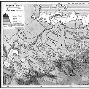
USSR, map of Union of Soviet Socialist Republics, illustrated with pictures

![]()
Wall Art and Photo Gifts from Fine Art Storehouse
USSR, map of Union of Soviet Socialist Republics, illustrated with pictures
Unleash your creativity and transform your space into a visual masterpiece!
Dorling Kindersley
Media ID 13558383
© This content is subject to copyright
Communism Country Eastern Europe Former Soviet Union Geography Russia Soviet Union Ussr Union Of Soviet Socialist Republics
FEATURES IN THESE COLLECTIONS
> Fine Art Storehouse
> Photo Libraries
> Dorling Kindersley Prints
EDITORS COMMENTS
This vibrant and detailed print showcases a captivating map of the Union of Soviet Socialist Republics (USSR), illustrated with pictures, capturing the essence of this historic nation. The image is presented in full color against a clean white background, allowing every intricate detail to come to life. The map represents the vast expanse of the USSR, spanning across Eastern Europe and parts of Asia. It serves as a visual representation of communism's stronghold during its existence. Each region is clearly defined, highlighting the diverse landscapes and physical geography that shaped this mighty country. Illustrated with precision and artistry, this unique piece combines both cartography and illustration techniques seamlessly. The addition of pictures throughout the map adds depth and character to each area depicted, offering glimpses into various aspects of Soviet life – from iconic landmarks to cultural symbols. As we gaze upon this horizontal masterpiece by Dorling Kindersley, it reminds us not only of Russia's immense size but also its significant influence on global politics during its time as a superpower. This print serves as an educational tool for those interested in exploring European history or studying geopolitical shifts. Whether you are an enthusiast for historical maps or simply appreciate fine art photography, this striking image will undoubtedly captivate your imagination while providing insight into one of the most influential nations in modern history – the Union of Soviet Socialist Republics (USSR).
MADE IN THE UK
Safe Shipping with 30 Day Money Back Guarantee
FREE PERSONALISATION*
We are proud to offer a range of customisation features including Personalised Captions, Color Filters and Picture Zoom Tools
SECURE PAYMENTS
We happily accept a wide range of payment options so you can pay for the things you need in the way that is most convenient for you
* Options may vary by product and licensing agreement. Zoomed Pictures can be adjusted in the Basket.