Home > Arts > Artists > B > Charles Marie Rigobert Bonne
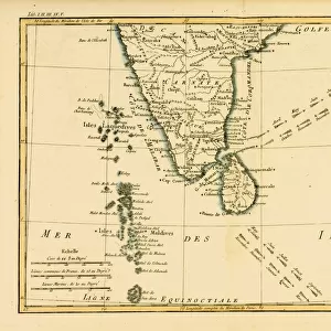
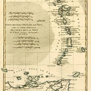
Southern India and Ceylon, from Atlas de Toutes les Parties Connues du Globe

![]()
Wall Art and Photo Gifts from Fine Art Finder
Southern India and Ceylon, from Atlas de Toutes les Parties Connues du Globe
KW205854 Southern India and Ceylon, from Atlas de Toutes les Parties Connues du Globe Terrestre by Guillaume Raynal (1713-96), published J L Pellet, Geneva, 1780 (coloured engraving) by Bonne, Charles Marie Rigobert (1727-95); Private Collection; Ken Welsh; French, out of copyright
Media ID 12755451
© www.bridgemanimages.com
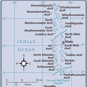
Indian Ocean South Sri Lanka Maldives Trade Winds
FEATURES IN THESE COLLECTIONS
> Arts
> Artists
> B
> Charles Marie Rigobert Bonne
> Fine Art Finder
> Artists
> Charles Marie Rigobert Bonne
> Fine Art Finder
> Maps (celestial & Terrestrial)
> Maps and Charts
> India
EDITORS COMMENTS
This print showcases the stunning beauty of Southern India and Ceylon, captured from an ancient atlas that holds a wealth of knowledge about our globe. The map, created by Guillaume Raynal in the late 18th century, offers a glimpse into the historical significance and geographical features of this region. The vibrant colors used in this colored engraving bring to life the diverse landscapes that adorn these lands. From lush green forests to majestic mountains, it is evident why Southern India and Ceylon have been revered throughout history for their natural wonders. As we gaze upon this image, we are transported back in time to an era when trade winds dominated these waters. The Indian Ocean stretches out before us, its vastness connecting distant lands and cultures. It serves as a reminder of the rich maritime history that has shaped these regions for centuries. This print not only captures the physical beauty but also symbolizes the importance of exploration and discovery. It represents a time when cartographers like Charles Marie Rigobert Bonne meticulously documented every known part of our world on maps like this one. Preserved within private collections today, prints like these allow us to appreciate both the artistry involved in their creation and gain insight into how our understanding of geography has evolved over time. They serve as reminders of our collective human curiosity and desire to explore beyond what is familiar - traits that continue to drive us forward even today.
MADE IN THE UK
Safe Shipping with 30 Day Money Back Guarantee
FREE PERSONALISATION*
We are proud to offer a range of customisation features including Personalised Captions, Color Filters and Picture Zoom Tools
SECURE PAYMENTS
We happily accept a wide range of payment options so you can pay for the things you need in the way that is most convenient for you
* Options may vary by product and licensing agreement. Zoomed Pictures can be adjusted in the Basket.