Home > Arts > Artists > W > Robert Walker
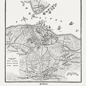
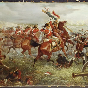
Plan of the Siege of Sebastopol 1854-55, engraved by Robert Walker, pub. William Mackenzie, c

![]()
Wall Art and Photo Gifts from Fine Art Finder
Plan of the Siege of Sebastopol 1854-55, engraved by Robert Walker, pub. William Mackenzie, c
XCF324373 Plan of the Siege of Sebastopol 1854-55, engraved by Robert Walker, pub. William Mackenzie, c.1860 (coloured engraving) by English School, (19th century); Private Collection; English, out of copyright
Media ID 12851357
© www.bridgemanart.com
British Army Crimea Crimean War Forces Geographical Mapping Military Strategy Ottoman Positions Sevastopol Tactics
FEATURES IN THESE COLLECTIONS
> Arts
> Artists
> O
> Ottoman School Ottoman School
> Arts
> Artists
> W
> Robert Walker
> Europe
> Russia
> Related Images
> Fine Art Finder
> Schools
> English School
> Historic
> Battles
> Related Images
> Maps and Charts
> Related Images
EDITORS COMMENTS
This print showcases the "Plan of the Siege of Sebastopol 1854-55" a remarkable engraved artwork by Robert Walker, published by William Mackenzie around 1860. The colored engraving, created by an English School artist from the 19th century, is now part of a private collection. The image takes us back to one of history's most significant conflicts - the Crimean War. It depicts the strategic city of Sevastopol and its surroundings during this intense period. The British, French, Ottoman, and Russian forces are meticulously mapped out on this detailed piece of cartography. As we delve into this historical artifact, it becomes evident that military strategy and tactics played a crucial role in shaping the outcome of battles fought in this region. The positioning and movements of troops can be observed with precision as they navigate through challenging terrains towards their objectives. Sevastopol's importance as a port city is highlighted in this artwork; its harbor along the coast served as a vital supply route for both sides involved in the conflict. This map offers valuable insights into how each force aimed to gain control over key positions within Sevastopol while defending against enemy advances. With its rich historical context and intricate details, this print serves as an invaluable resource for understanding not only the events surrounding the Siege but also broader aspects such as geography and cartography during that era.
MADE IN THE UK
Safe Shipping with 30 Day Money Back Guarantee
FREE PERSONALISATION*
We are proud to offer a range of customisation features including Personalised Captions, Color Filters and Picture Zoom Tools
SECURE PAYMENTS
We happily accept a wide range of payment options so you can pay for the things you need in the way that is most convenient for you
* Options may vary by product and licensing agreement. Zoomed Pictures can be adjusted in the Basket.