Home > Asia > Iran > Lakes > Caspian Sea
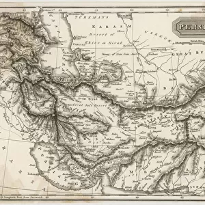
Partial Map of Middle East in the 1890s, from The Citizens Atlas of the World

![]()
Wall Art and Photo Gifts from Fine Art Finder
Partial Map of Middle East in the 1890s, from The Citizens Atlas of the World
KW287949 Partial Map of Middle East in the 1890s, from The Citizens Atlas of the World, published in London, c.1899 (colour litho) by English School, (19th century); Private Collection; Ken Welsh; English, out of copyright
Media ID 12802703
© www.bridgemanimages.com
Arabia Black Sea Cartography Caspian Sea Euphrates Iran Mediterranean Sea Persia Tigris
FEATURES IN THESE COLLECTIONS
> Asia
> Iran
> Lakes
> Caspian Sea
> Asia
> Turkey
> Related Images
> Europe
> United Kingdom
> England
> London
> Related Images
> Fine Art Finder
> Maps (celestial & Terrestrial)
> Fine Art Finder
> Schools
> English School
> Maps and Charts
> World
EDITORS COMMENTS
This print showcases a partial map of the Middle East in the 1890s, taken from The Citizens Atlas of the World. Published in London around 1899, this color lithograph offers a glimpse into the intricate cartography of that era. With its rich hues and meticulous details, it transports us back to a time when exploration and discovery were at their peak. The map encompasses various regions including the Mediterranean Sea, Black Sea, Caspian Sea, Turkey, Persia (modern-day Iran), Egypt, Arabia, and Iran. It highlights prominent geographical features such as the Tigris and Euphrates rivers which have played significant roles throughout history. As we delve into this historical artifact preserved within a private collection today, we are reminded of how maps serve as windows to our past. They not only provide navigational guidance but also offer insights into political boundaries and cultural landscapes that have evolved over time. This particular print is an exquisite representation of early 19th-century English cartography. Its vibrant colors bring life to each contour line and symbolize the diversity found within these lands. Whether used for educational purposes or simply admired for its artistic value, this image invites us to explore an era long gone by while appreciating the craftsmanship behind it.
MADE IN THE UK
Safe Shipping with 30 Day Money Back Guarantee
FREE PERSONALISATION*
We are proud to offer a range of customisation features including Personalised Captions, Color Filters and Picture Zoom Tools
SECURE PAYMENTS
We happily accept a wide range of payment options so you can pay for the things you need in the way that is most convenient for you
* Options may vary by product and licensing agreement. Zoomed Pictures can be adjusted in the Basket.