Home > Arts > Artists > V > Sebastien Le Prestre de Vauban
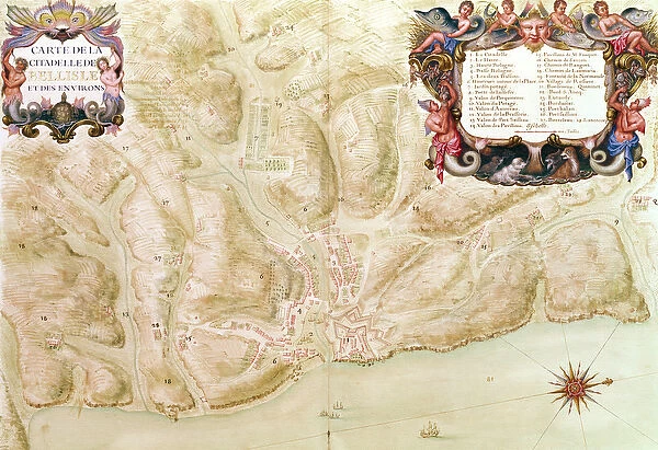
Ms 988 volume 3 fol. 33 Map of the town and citadel of Bellisle, from the Atlas Louis XIV
![]()

Wall Art and Photo Gifts from Fine Art Finder
Ms 988 volume 3 fol. 33 Map of the town and citadel of Bellisle, from the Atlas Louis XIV
XIR230510 Ms 988 volume 3 fol.33 Map of the town and citadel of Bellisle, from the Atlas Louis XIV, 1683-88 (gouache on paper) by Vauban, Sebastien Le Prestre de (1633-1707); Service Historique de L Armee et de L Air, Vincennes, France; (add.info.: recueil des cartes des places de guerre des provinces du royaume; ville et citadelle de Bellisle; ); French, out of copyright
Media ID 12766450
© www.bridgemanimages.com
Atlantic Ocean Belle Ile Belle Isle Breton Cartouche Citadel Fortification Fortifications Fortified Morbihan Star Defence System Belle Ile En Mer Recueil
FEATURES IN THESE COLLECTIONS
> Arts
> Artists
> V
> Sebastien Le Prestre de Vauban
> Europe
> France
> Canton
> Morbihan
> Fine Art Finder
> Artists
> Sebastien Le Prestre de Vauban
> Maps and Charts
> Star Charts
EDITORS COMMENTS
This print showcases the intricate "Map of the town and citadel of Bellisle" from the renowned Atlas Louis XIV, created by Sebastien Le Prestre de Vauban in 1683-88. The map, rendered in exquisite gouache on paper, offers a fascinating glimpse into the fortified coastal town of Bellisle, located in Brittany, France. Vauban's expertise as a military engineer is evident in this meticulously detailed plan. The fortifications surrounding Bellisle are depicted with precision and adorned with decorative cartouches that add to its artistic appeal. The strategic star defense system employed by Vauban can be observed, showcasing his innovative approach to fortification design. The island setting of Belle Isle en Mer adds an enchanting element to this historical artwork. Situated amidst the vast Atlantic Ocean, this fortified town served as a crucial stronghold during Louis XIV's reign. Its significance as a coastal defense point is highlighted by its inclusion in the comprehensive collection known as "Recueil des Cartes des Places de Guerre des Provinces du Royaume". Preserved by the Service Historique de L'Armee et de L'Air in Vincennes, France, this extraordinary piece provides valuable insights into both military strategy and artistic craftsmanship of the era. As we admire this stunning print today, we are transported back to a time when fortified towns like Bellisle played an essential role in protecting their nations against potential threats from land or sea.
MADE IN THE UK
Safe Shipping with 30 Day Money Back Guarantee
FREE PERSONALISATION*
We are proud to offer a range of customisation features including Personalised Captions, Color Filters and Picture Zoom Tools
SECURE PAYMENTS
We happily accept a wide range of payment options so you can pay for the things you need in the way that is most convenient for you
* Options may vary by product and licensing agreement. Zoomed Pictures can be adjusted in the Basket.


