Home > Africa > Egypt > Maps
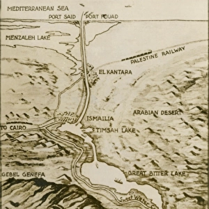
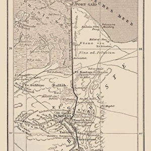
Map of the Suez Canal, c. 1869 (engraving) (b / w photo)
 (b / w photo)")
![]()
Wall Art and Photo Gifts from Fine Art Finder
Map of the Suez Canal, c. 1869 (engraving) (b / w photo)
XJF323065 Map of the Suez Canal, c.1869 (engraving) (b/w photo) by French School, (19th century); Private Collection; (add.info.: canal opened on November 17th 1869; ); French, out of copyright
Media ID 12850675
© www.bridgemanart.com
Aerial View Mediterranean Route Terrain
FEATURES IN THESE COLLECTIONS
> Aerial Photography
> Related Images
> Fine Art Finder
> Maps (celestial & Terrestrial)
> Fine Art Finder
> Schools
> French School
> Maps and Charts
> Related Images
EDITORS COMMENTS
This print showcases a historical treasure - the Map of the Suez Canal, dating back to approximately 1869. Created by the French School in the 19th century, this engraving offers a fascinating glimpse into one of Egypt's most significant engineering marvels. The Suez Canal, which officially opened on November 17th, 1869, is beautifully depicted in this aerial view. The intricate details of its route and terrain are meticulously captured, allowing viewers to appreciate the sheer magnitude of this man-made waterway connecting the Mediterranean Sea with the Red Sea. As we gaze upon this remarkable piece from a private collection, our eyes are drawn to Egypt's stunning coastline and its strategic location between two major bodies of water. This map not only serves as an artistic representation but also as a testament to human ingenuity and determination. While exploring every nook and cranny of this engraving, it becomes evident that it holds immense historical value. It provides us with insights into how early engineers envisioned and executed such an ambitious project. With its rich history and undeniable beauty, this Map of the Suez Canal invites us to reflect on mankind's ability to shape landscapes for greater connectivity. As we admire this masterpiece from www. bridgemanart. com without commercial intentions or mentioning any specific company associated with it; let us celebrate both artistry and innovation intertwined within these delicate lines etched by talented hands long ago.
MADE IN THE UK
Safe Shipping with 30 Day Money Back Guarantee
FREE PERSONALISATION*
We are proud to offer a range of customisation features including Personalised Captions, Color Filters and Picture Zoom Tools
SECURE PAYMENTS
We happily accept a wide range of payment options so you can pay for the things you need in the way that is most convenient for you
* Options may vary by product and licensing agreement. Zoomed Pictures can be adjusted in the Basket.