Home > Europe > United Kingdom > England > London > Royalty
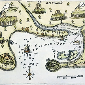
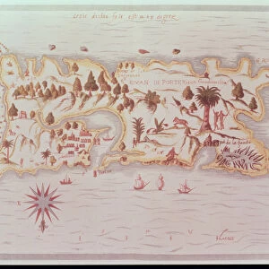
Map of the island of Puerto Rico, 1599

![]()
Wall Art and Photo Gifts from Fine Art Finder
Map of the island of Puerto Rico, 1599
XTD75433 Map of the island of Puerto Rico, 1599 by Champlain, Samuel de (1567-1635); Royal Commonwealth Society, London, UK; French, out of copyright
Media ID 12935871
© www.bridgemanart.com
Boar Caribbean Cabo Rojo Natives
FEATURES IN THESE COLLECTIONS
> Arts
> Artists
> C
> Samuel de Champlain
> Europe
> United Kingdom
> England
> London
> Royalty
> Europe
> United Kingdom
> Maps
> Fine Art Finder
> Artists
> Samuel de Champlain
> Fine Art Finder
> Maps (celestial & Terrestrial)
> Maps and Charts
> Related Images
> North America
> Puerto Rico
> Maps
EDITORS COMMENTS
This print showcases a historical gem, the "Map of the island of Puerto Rico, 1599" by Samuel de Champlain. Preserved by the Royal Commonwealth Society in London, UK, this French masterpiece takes us back to an era long gone. The map's intricate details transport us to Cabo Rojo, where lush trees sway gently under the Caribbean sun. As we delve deeper into this artwork, our eyes are drawn to scenes of adventure and exploration. A group of natives can be seen engaged in a thrilling boar hunt amidst the dense foliage. Their skilled hunting techniques are evident as they navigate through this vibrant landscape. One intriguing aspect is that Champlain has ingeniously depicted his compass upside down on this map. This clever twist challenges our perception and invites us to explore beyond conventional boundaries. The historical significance of this piece cannot be overstated; it offers valuable insights into Puerto Rico's past and its indigenous cultures. It serves as a testament to Champlain's meticulous craftsmanship and dedication to cartography. Through www. bridgemanart. com's fine art reproduction expertise, we now have access to this remarkable work from centuries ago. Let yourself be captivated by its beauty and immerse yourself in the rich history it represents - a true treasure for any admirer of art or lover of Puerto Rican heritage.
MADE IN THE UK
Safe Shipping with 30 Day Money Back Guarantee
FREE PERSONALISATION*
We are proud to offer a range of customisation features including Personalised Captions, Color Filters and Picture Zoom Tools
SECURE PAYMENTS
We happily accept a wide range of payment options so you can pay for the things you need in the way that is most convenient for you
* Options may vary by product and licensing agreement. Zoomed Pictures can be adjusted in the Basket.