Home > Arts > Artists > V > Antonio Giovanni de Varese
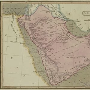
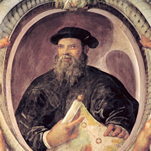
Map of the Countries of the Persian Golf, from the Sala Del Mappamondo

![]()
Wall Art and Photo Gifts from Fine Art Finder
Map of the Countries of the Persian Golf, from the Sala Del Mappamondo
XIR315969 Map of the Countries of the Persian Golf, from the Sala Del Mappamondo (Hall of the World Maps) (fresco) by Varese, Antonio Giovanni de (16th century); Villa Farnese, Caprarola, Lazio, Italy; (add.info.: Carte des pays du Golfe persique, salle de la Mappemonde; ); Italian, out of copyright
Media ID 12847164
© www.bridgemanimages.com
Cartography Iran Persia Saudi Arabia
FEATURES IN THESE COLLECTIONS
> Arts
> Artists
> V
> Antonio Giovanni de Varese
> Asia
> Saudi Arabia
> Maps
> Europe
> Italy
> Lazio
> Related Images
> Europe
> Italy
> Lombardy
> Varese
> Europe
> Italy
> Sports
> Golf
> Fine Art Finder
> Artists
> Antonio Giovanni de Varese
> Fine Art Finder
> Maps (celestial & Terrestrial)
> Maps and Charts
> Italy
> Maps and Charts
> World
EDITORS COMMENTS
This print showcases the exquisite "Map of the Countries of the Persian Gulf" from the Sala Del Mappamondo (Hall of the World Maps) in Villa Farnese, Caprarola, Italy. Painted by Antonio Giovanni de Varese in the 16th century, this fresco is a true masterpiece that captures both cartography and artistry. The map depicts an intricate representation of the Persian Gulf region, highlighting its coastal areas and countries such as Persia (modern-day Iran) and Saudi Arabia. Its medieval Renaissance style adds a touch of historical charm to this remarkable piece. With its vibrant colors and meticulous details, this mural transports viewers back in time to an era when exploration was at its peak. It serves as a testament to humanity's curiosity about distant lands and their desire to understand our world better. As we gaze upon this print, we can't help but appreciate how it seamlessly combines artistic beauty with geographical accuracy. The fine craftsmanship exhibited here reminds us of the importance placed on maps during ancient times for navigation purposes. Whether you're an art enthusiast or a history buff, this print offers a glimpse into centuries past while celebrating human ingenuity. Let it inspire you to embark on your own journey of discovery – be it through exploring new places or delving deeper into our rich cultural heritage.
MADE IN THE UK
Safe Shipping with 30 Day Money Back Guarantee
FREE PERSONALISATION*
We are proud to offer a range of customisation features including Personalised Captions, Color Filters and Picture Zoom Tools
SECURE PAYMENTS
We happily accept a wide range of payment options so you can pay for the things you need in the way that is most convenient for you
* Options may vary by product and licensing agreement. Zoomed Pictures can be adjusted in the Basket.