Home > Arts > Artists > B > Charles Marie Rigobert Bonne
Eastern Canada, Newfoundland, Nova Scotia and St John Island, from Atlas de

![]()
Wall Art and Photo Gifts from Fine Art Finder
Eastern Canada, Newfoundland, Nova Scotia and St John Island, from Atlas de
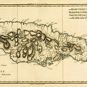
KW205896 Eastern Canada, Newfoundland, Nova Scotia and St John Island, from Atlas de Toutes les Parties Connues du Globe Terrestre by Guillaume Raynal (1713-96), published J L Pellet, Geneva, 1780 (coloured engraving) by Bonne, Charles Marie Rigobert (1727-95); Private Collection; Ken Welsh; French, out of copyright
Media ID 12755487
© www.bridgemanimages.com
Prince Edward Island Quebec Gulf Of St Lawrence
FEATURES IN THESE COLLECTIONS
> Arts
> Artists
> B
> Charles Marie Rigobert Bonne
> Fine Art Finder
> Artists
> Charles Marie Rigobert Bonne
> Maps and Charts
> Related Images
> North America
> Canada
> Maps
> North America
> Canada
> Related Images
> North America
> Related Images
> Popular Themes
> North Island
EDITORS COMMENTS
This print takes us on a historical journey through Eastern Canada, showcasing the stunning landscapes of Newfoundland, Nova Scotia, and St. John Island. The intricate details of this 18th-century map, created by renowned cartographer Guillaume Raynal and published by J L Pellet in Geneva in 1780, offer a glimpse into the knowledge and exploration of that era. The vibrant colors bring to life the vastness of these Canadian provinces as they stretch across the page. From Prince Edward Island to the Gulf of St. Lawrence and Quebec, each region is meticulously depicted with precision and accuracy. As we gaze upon this artwork from Bonne's collection, we are transported back in time to an age when maps were not only navigational tools but also works of art. Every contour line and coastal feature tells a story of discovery and adventure. This private collection piece captures our imagination with its rich history and cultural significance. It reminds us of the countless explorers who braved unknown territories to uncover new lands for future generations. Whether you have personal ties to Eastern Canada or simply appreciate the beauty found within antique maps, this print serves as a testament to human curiosity and our eternal quest for knowledge about our world.
MADE IN THE UK
Safe Shipping with 30 Day Money Back Guarantee
FREE PERSONALISATION*
We are proud to offer a range of customisation features including Personalised Captions, Color Filters and Picture Zoom Tools
SECURE PAYMENTS
We happily accept a wide range of payment options so you can pay for the things you need in the way that is most convenient for you
* Options may vary by product and licensing agreement. Zoomed Pictures can be adjusted in the Basket.