Home > Europe > United Kingdom > Heritage Sites > Maritime Greenwich
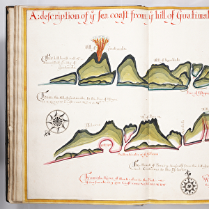
This type of early vellum sea chart originated in the Mediterranean in the 13th century., c.1610 (manuscript)
")
![]()
Wall Art and Photo Gifts from Fine Art Finder
This type of early vellum sea chart originated in the Mediterranean in the 13th century., c.1610 (manuscript)
7339780 This type of early vellum sea chart originated in the Mediterranean in the 13th century., c.1610 (manuscript) by Unknown Artist, (17th century); 40x56 cm; National Maritime Museum, London, UK; (add.info.: Creator: unknown
This type of early vellum sea chart originated in the Mediterranean in the 13th century. They are often referred to as 'portulan' or 'portolan' charts, a name taken from the written sailing directions, 'portolani', which they supplemented and superseded, although this attribution is not always technically correct. They were drawn in coloured ink on vellum.); © National Maritime Museum, Greenwich, London
Media ID 38515840
© © National Maritime Museum, Greenwich, London / Bridgeman Images
Mediterranea Mediterranean Mediterrean Meditteranean
FEATURES IN THESE COLLECTIONS
> Europe
> United Kingdom
> Heritage Sites
> Maritime Greenwich
> Fine Art Finder
> Artists
> Unknown Artist
> Fine Art Finder
> Artists
> William Hack
EDITORS COMMENTS
This stunning early vellum sea chart, dating back to around 1610, is a prime example of the intricate and detailed maps that originated in the Mediterranean in the 13th century. Created by an unknown artist from the 17th century, this piece measures 40x56 cm and is housed at the National Maritime Museum in London.
Known as 'portulan' or 'portolan' charts, these navigational tools were essential for sailors during this time period. They provided written sailing directions known as 'portolani', which helped guide ships safely across the seas. Although technically not always correct to attribute these charts solely to portolani, they were still invaluable resources for seafarers.
Drawn with colored ink on vellum, these sea charts were not only functional but also works of art in their own right. The vibrant colors used on this particular chart add to its visual appeal and historical significance.
This piece offers a glimpse into a bygone era when exploration and navigation relied heavily on such meticulously crafted maps. It serves as a reminder of the ingenuity and skill of those who came before us, paving the way for future generations of explorers and cartographers.
MADE IN THE UK
Safe Shipping with 30 Day Money Back Guarantee
FREE PERSONALISATION*
We are proud to offer a range of customisation features including Personalised Captions, Color Filters and Picture Zoom Tools
SECURE PAYMENTS
We happily accept a wide range of payment options so you can pay for the things you need in the way that is most convenient for you
* Options may vary by product and licensing agreement. Zoomed Pictures can be adjusted in the Basket.