Home > Europe > United Kingdom > England > London > Museums > National Maritime Museum
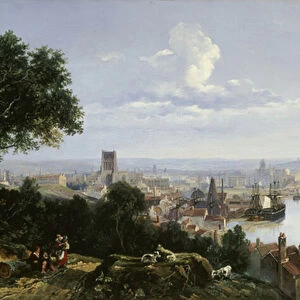
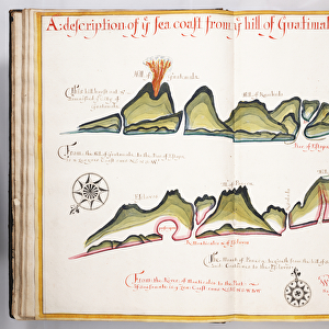
Quillota and Valpariso, South American Pacific coast, 1685 (manuscript)
")
![]()
Wall Art and Photo Gifts from Fine Art Finder
Quillota and Valpariso, South American Pacific coast, 1685 (manuscript)
7339772 Quillota and Valpariso, South American Pacific coast, 1685 (manuscript) by Hack, William (17th Century); 40x50 cm; National Maritime Museum, London, UK; (add.info.: Creator: William Hack
Bound in 'A Wagoner of the South Sea describeing the sea coast from acapulco to Albemarle isle', an English translation of a Spanish derrotero captured from the Spanish ship 'Rosario' by Captain Bartholomew Sharpe in 1680. Hack made multiple copies of this atlas. This one was presented to James II.); © National Maritime Museum, Greenwich, London
Media ID 38177070
© © National Maritime Museum, Greenwich, London / Bridgeman Images
Cartography Coast Line Latin America Latine America
FEATURES IN THESE COLLECTIONS
> Arts
> Artists
> J
> William James
> Europe
> United Kingdom
> England
> London
> Boroughs
> Greenwich
> Europe
> United Kingdom
> England
> London
> Museums
> Greenwich Heritage Centre
> Europe
> United Kingdom
> England
> London
> Museums
> National Maritime Museum
> Europe
> United Kingdom
> England
> London
> Towns
> Greenwich
> Europe
> United Kingdom
> Heritage Sites
> Maritime Greenwich
> Europe
> United Kingdom
> Maps
> Fine Art Finder
> Artists
> William Hack
> Maps and Charts
> Early Maps
EDITORS COMMENTS
This stunning print captures the beauty of Quillota and Valpariso on the South American Pacific coast in 1685. The intricate details of this manuscript, created by William Hack in the 17th century, showcase a vibrant and colorful map that highlights the coastline with precision.
Bound in 'A Wagoner of the South Sea describeing the sea coast from Acapulco to Albemarle Isle', this English translation of a Spanish derrotero captured from the Spanish ship 'Rosario' by Captain Bartholomew Sharpe in 1680 is a true treasure. Hack's multiple copies of this atlas were highly sought after, with one even being presented to James II.
The rich history and craftsmanship displayed in this image evoke a sense of wonder and curiosity about the exploration and navigation techniques used during that time period. The colors are vivid and captivating, drawing viewers into a world where cartography was both an art form and a practical tool for sailors navigating unknown waters.
As you gaze upon this piece, you can almost feel the salty breeze coming off the sea as ships sail along the coastlines depicted with such care and skill. It serves as a reminder of how important maps were for early explorers venturing into uncharted territories, seeking new lands and opportunities beyond their wildest dreams.
MADE IN THE UK
Safe Shipping with 30 Day Money Back Guarantee
FREE PERSONALISATION*
We are proud to offer a range of customisation features including Personalised Captions, Color Filters and Picture Zoom Tools
SECURE PAYMENTS
We happily accept a wide range of payment options so you can pay for the things you need in the way that is most convenient for you
* Options may vary by product and licensing agreement. Zoomed Pictures can be adjusted in the Basket.