Home > Arts > Artists > S > Thomas Sulman
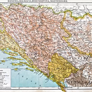
Map to illustrate the Austrian Military Occupation of Bosnia and Herzegovina (engraving)
")
![]()
Wall Art and Photo Gifts from Fine Art Finder
Map to illustrate the Austrian Military Occupation of Bosnia and Herzegovina (engraving)
1621883 Map to illustrate the Austrian Military Occupation of Bosnia and Herzegovina (engraving) by English School, (19th century); Private Collection; (add.info.: Map to illustrate the Austrian Military Occupation of Bosnia and Herzegovina. Illustration for The Illustrated London News, 31 August 1878.
English School (19th Century)); Look and Learn / Illustrated Papers Collection
Media ID 23089280
© Look and Learn / Illustrated Papers Collection / Bridgeman Images
Bosnia Bosniaque Congress Of Berlin Herzegovina Illustrate
FEATURES IN THESE COLLECTIONS
> Arts
> Artists
> S
> Thomas Sulman
> Europe
> Bosnia and Herzegovina
> Maps
> Fine Art Finder
> Artists
> English School
> Fine Art Finder
> Artists
> Thomas Sulman
> Maps and Charts
> Bosnia and Herzegovina
EDITORS COMMENTS
This print showcases a historical engraving titled "Map to illustrate the Austrian Military Occupation of Bosnia and Herzegovina" by an English School artist from the 19th century. The map, now part of a private collection, was originally created as an illustration for The Illustrated London News on August 31,1878. The intricate details of this engraving transport us back to a significant moment in European history - the Congress of Berlin. This event marked the Austrian military occupation of Bosnia and Herzegovina, depicted vividly on this map. It serves as a visual guide to understand the territorial changes that occurred during this period. As we examine this artwork closely, we are reminded of the power dynamics at play during that time. The Austrians sought control over these regions in order to expand their influence within Europe. This map not only represents political maneuvering but also reflects the complex relationships between nations. Through its precise engravings and meticulous attention to detail, this piece offers valuable insights into European history and geography. It allows us to delve deeper into understanding how borders were redrawn and territories were divided during moments of conflict and negotiation. Bridgeman Images has once again provided us with an exceptional glimpse into our past through their remarkable collection. This print is sure to captivate any history enthusiast or art lover who appreciates both beauty and educational value intertwined within one masterpiece.
MADE IN THE UK
Safe Shipping with 30 Day Money Back Guarantee
FREE PERSONALISATION*
We are proud to offer a range of customisation features including Personalised Captions, Color Filters and Picture Zoom Tools
SECURE PAYMENTS
We happily accept a wide range of payment options so you can pay for the things you need in the way that is most convenient for you
* Options may vary by product and licensing agreement. Zoomed Pictures can be adjusted in the Basket.