Home > Europe > United Kingdom > England > London > Museums > National Maritime Museum
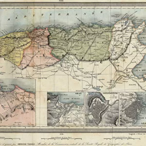
Plan of Brest, 1724 (watercolour)
")
![]()
Wall Art and Photo Gifts from Fine Art Finder
Plan of Brest, 1724 (watercolour)
7339803 Plan of Brest, 1724 (watercolour) by Unknown artist, (18th century); 39x53.5 cm; National Maritime Museum, London, UK; (add.info.: Creator: unknown
Bound sheet. Col. ms. Scale: [ca. 1:7 200 (bar)]. Cartographic Note: Scale in toises. Contents Note: Key.
From an atlas of seventeen plans of French ports: Recueil des plans ou cartes des principaux ports de royaume'.); © National Maritime Museum, Greenwich, London
Media ID 38410136
© © National Maritime Museum, Greenwich, London / Bridgeman Images
Watercolors Watercolour Paint Geographer
FEATURES IN THESE COLLECTIONS
> Europe
> United Kingdom
> England
> London
> Boroughs
> Greenwich
> Europe
> United Kingdom
> England
> London
> Museums
> Greenwich Heritage Centre
> Europe
> United Kingdom
> England
> London
> Museums
> National Maritime Museum
> Europe
> United Kingdom
> England
> London
> Towns
> Greenwich
> Europe
> United Kingdom
> Heritage Sites
> Maritime Greenwich
> Europe
> United Kingdom
> Maps
> Fine Art Finder
> Artists
> Thomas Baxter
> Fine Art Finder
> Artists
> Unknown Artist
> Maps and Charts
> Early Maps
EDITORS COMMENTS
This stunning watercolour print of the Plan of Brest, 1724 offers a glimpse into the intricate cartography of the 18th century. Created by an unknown artist, this detailed map measures 39x53.5 cm and is housed in the National Maritime Museum in London, UK.
The map is part of an atlas featuring seventeen plans of French ports, titled 'Recueil des plans ou cartes des principaux ports de royaume'. The bound sheet includes colored manuscript annotations and a key for reference. The scale is approximately 1:7,200 toises.
The vibrant colors used in this watercolor painting bring to life the geography and layout of Brest in France during the early 18th century. Each line and symbol on the map tells a story of navigation and exploration in Europe at that time.
This artwork serves as both a historical document and a work of art, showcasing the skill and precision required for cartography in the 18th century. It invites viewers to immerse themselves in a world where maps were not just tools for navigation but also pieces of visual storytelling.
Overall, this Plan of Brest from 1724 captures a moment in history with its meticulous details and vibrant colors, making it a valuable addition to any collection or display focused on European cartography.
MADE IN THE UK
Safe Shipping with 30 Day Money Back Guarantee
FREE PERSONALISATION*
We are proud to offer a range of customisation features including Personalised Captions, Color Filters and Picture Zoom Tools
SECURE PAYMENTS
We happily accept a wide range of payment options so you can pay for the things you need in the way that is most convenient for you
* Options may vary by product and licensing agreement. Zoomed Pictures can be adjusted in the Basket.