Home > Africa > Algeria > Maps
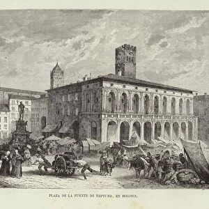
Geographic atlas: view of the Mediterranean Sea and the coasts of Barbaria (Algeria, Tunisia, Tripolitan). Atlas de Nicolas et Guillaume Sanson, 1670. Municipal Library of Marseille
. Atlas de Nicolas et Guillaume Sanson, 1670. Municipal Library of Marseille")
![]()
Wall Art and Photo Gifts from Fine Art Finder
Geographic atlas: view of the Mediterranean Sea and the coasts of Barbaria (Algeria, Tunisia, Tripolitan). Atlas de Nicolas et Guillaume Sanson, 1670. Municipal Library of Marseille
JEB4874639 Geographic atlas: view of the Mediterranean Sea and the coasts of Barbaria (Algeria, Tunisia, Tripolitan). Atlas de Nicolas et Guillaume Sanson, 1670. Municipal Library of Marseille; (add.info.: Geographic atlas: view of the Mediterranean Sea and the coasts of Barbaria (Algeria, Tunisia, Tripolitan). Atlas de Nicolas et Guillaume Sanson, 1670. Municipal Library of Marseille); © Jean Bernard. All rights reserved 2023
Media ID 38265886
© © Jean Bernard. All rights reserved 2024 / Bridgeman Images
17th Centuries Africa African African Algeria Algeria Algerian Algerian Algerians Algerie Arab Country Geographical Map Maghrebi Maghrebian Maghrebin Maghrebine Mediterranean Sea North African Tunisia Tunisian
FEATURES IN THESE COLLECTIONS
> Africa
> Algeria
> Related Images
> Africa
> Tunisia
> Related Images
> Fine Art Finder
> Artists
> Spanish School (after)
> Maps and Charts
> Early Maps
EDITORS COMMENTS
This stunning print captures a glimpse of history with a view of the Mediterranean Sea and the coasts of Barbaria (Algeria, Tunisia, Tripolitan) from the 17th century. The intricate details on this Geographic atlas by Nicolas et Guillaume Sanson in 1670 are truly mesmerizing, showcasing the beauty and complexity of cartography during that time.
The Municipal Library of Marseille houses this remarkable piece, offering a window into the past for all who gaze upon it. The rich cultural heritage of North Africa is depicted in this map, highlighting the Arab civilization and diverse landscapes of Algeria, Tunisia, and Tripolitan.
As we admire this historical artifact, we are reminded of the importance of geography in shaping our understanding of the world. The Mediterranean Sea serves as a connecting point between continents, while the coasts of Barbaria reveal a tapestry of civilizations and cultures that have thrived along these shores for centuries.
Through Jean Bernard's lens, we are transported back in time to explore the wonders of early cartography and marvel at how our ancestors navigated these lands long before modern technology. This print is not just an image but a gateway to exploration and discovery, inviting us to delve deeper into our shared history with each glance.
MADE IN THE UK
Safe Shipping with 30 Day Money Back Guarantee
FREE PERSONALISATION*
We are proud to offer a range of customisation features including Personalised Captions, Color Filters and Picture Zoom Tools
SECURE PAYMENTS
We happily accept a wide range of payment options so you can pay for the things you need in the way that is most convenient for you
* Options may vary by product and licensing agreement. Zoomed Pictures can be adjusted in the Basket.