Home > Arts > Artists > V > Sebastien Le Prestre de Vauban
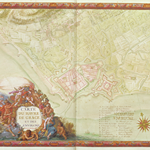
Ms. 988, Vol. 3 fol. 10 Map of Saint-Quentin, from the Atlas Louis XIV, 1683-88

![]()
Wall Art and Photo Gifts from Fine Art Finder
Ms. 988, Vol. 3 fol. 10 Map of Saint-Quentin, from the Atlas Louis XIV, 1683-88
XIR232103 Ms. 988, Vol.3 fol.10 Map of Saint-Quentin, from the Atlas Louis XIV, 1683-88 (gouache on paper) by Vauban, Sebastien Le Prestre de (1633-1707); Min. Defense - Service Historique de l Armee de Terre, France; French, out of copyright
Media ID 12766914
© www.bridgemanimages.com
Bastion Carte Citadel Fortification Fortified City Quentin Star Defence System
FEATURES IN THESE COLLECTIONS
> Arts
> Artists
> V
> Sebastien Le Prestre de Vauban
> Fine Art Finder
> Artists
> Sebastien Le Prestre de Vauban
> Maps and Charts
> Star Charts
EDITORS COMMENTS
This print showcases a remarkable piece of history, the "Ms. 988, Vol. 3 fol. 10 Map of Saint-Quentin" from the renowned Atlas Louis XIV. Created by Sebastien Le Prestre de Vauban between 1683 and 1688, this gouache on paper artwork offers a fascinating glimpse into the fortified city of Saint-Quentin in France. Vauban, an esteemed military engineer during the reign of Louis XIV, meticulously crafted this map to illustrate his innovative star defense system and fortification techniques. The detailed depiction highlights the strategic layout of bastions, citadels, and other defensive structures that protected Saint-Quentin. As we delve into this image's historical significance further, it becomes evident that it not only serves as a cartographic masterpiece but also provides invaluable insights into military architecture during that era. The intricate lines and precise detailing showcase Vauban's expertise in designing impregnable fortresses. The photograph captures every nuance of this magnificent work with exceptional clarity and precision. Its vibrant colors bring to life the meticulous brushstrokes employed by Vauban himself centuries ago. Preserved within the archives at Min Defense - Service Historique de l'Armee de Terre in France, this rare gem is now made accessible through Fine Art Finder's extensive collection. Whether you are an art enthusiast or a history buff seeking to explore ancient battle strategies and architectural marvels, this print is sure to transport you back in time to
MADE IN THE UK
Safe Shipping with 30 Day Money Back Guarantee
FREE PERSONALISATION*
We are proud to offer a range of customisation features including Personalised Captions, Color Filters and Picture Zoom Tools
SECURE PAYMENTS
We happily accept a wide range of payment options so you can pay for the things you need in the way that is most convenient for you
* Options may vary by product and licensing agreement. Zoomed Pictures can be adjusted in the Basket.