Home > Arts > Artists > V > Sebastien Le Prestre de Vauban
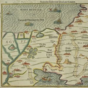
Ms. 988, Tome 3, fol. 39 Map of the town and citadel of Saint-Martin, Ile de Re

![]()
Wall Art and Photo Gifts from Fine Art Finder
Ms. 988, Tome 3, fol. 39 Map of the town and citadel of Saint-Martin, Ile de Re
XIR694798 Ms. 988, Tome 3, fol. 39 Map of the town and citadel of Saint-Martin, Ile de RA©, from the Atlas Louis XIV, 1683-88 (pen, ink & gouache) by Vauban, Sebastien Le Prestre de (1633-1707); Service Historique de L Armee et de L Air, Vincennes, France; (add.info.: Carte de la ville et citadelle de Saint-Martin en l Ile de Re; Recueil des cartes des places de guerre des provinces du royaume dit Atlas Louis XIV ; the reign of Louis XIV was a great period for French cartography, when mapping became an important tool in royal administration, planning and military strategy; the star defence design of the fortifications begun in the 1670s and completed by 1702 are typical of the many similar designs of Vauban, the foremost military engineer of the 17th century; ); French, out of copyright
Media ID 12923605
© www.bridgemanart.com
Atlantic Bastion Carte Cartouche Citadel Fortifications Fortified Ile De Re Isle Star Defence System Vauban Walls Saint Martin De Re
FEATURES IN THESE COLLECTIONS
> Arts
> Artists
> V
> Sebastien Le Prestre de Vauban
> Fine Art Finder
> Artists
> Sebastien Le Prestre de Vauban
> Maps and Charts
> Related Images
> Maps and Charts
> Star Charts
> North America
> Saint Martin
> Maps
> North America
> Saint Martin
> Related Images
EDITORS COMMENTS
This print showcases the intricate map of the town and citadel of Saint-Martin, Ile de Re, as depicted in the Atlas Louis XIV. Created by Sebastien Le Prestre de Vauban, a renowned military engineer of the 17th century, this pen, ink, and gouache masterpiece offers a glimpse into the strategic planning and royal administration during King Louis XIV's reign. The map reveals an impressive star defense system design that characterizes Vauban's fortifications. It is evident that meticulous attention was given to every detail in order to ensure optimal protection for this coastal town on the Atlantic coast of France. The fortified walls surrounding Saint-Martin de Re are prominently displayed with their bastions strategically placed along its perimeter. As one delves deeper into this historical artifact, it becomes clear that cartography played a vital role during this era. Mapping became an essential tool not only for military strategy but also for urban planning and administration purposes. The beauty of this image lies not only in its artistic execution but also in its ability to transport us back to a time when these fortifications were at their prime. This print serves as a testament to Vauban's genius and his contribution to French cartography. Whether you are fascinated by history or simply appreciate fine artistry, this remarkable piece will undoubtedly captivate your imagination and transport you back to an era where maps held immense power and significance.
MADE IN THE UK
Safe Shipping with 30 Day Money Back Guarantee
FREE PERSONALISATION*
We are proud to offer a range of customisation features including Personalised Captions, Color Filters and Picture Zoom Tools
SECURE PAYMENTS
We happily accept a wide range of payment options so you can pay for the things you need in the way that is most convenient for you
* Options may vary by product and licensing agreement. Zoomed Pictures can be adjusted in the Basket.